Cara Menggabungkan Beberapa Sertifikat Kompetensi Pendidik Menjadi Satu File Dalam Format .pdf

April 30, 2019 Add Comment

Salam semangat buat seluruh Pendidik dan Tenaga Kependidikan. Setelah di postingan sebelumnya kita membahas tentang Jenis Sertifikat Kompetensi Pendidik atau Kepala Satuan PAUD untuk Unggah di SISPENA 2.0. Selanjutnya, dipostingan ini admin akan menjelaskan tentang Bagaimana Caranya Beberapa Sertifikat yang di miliki Pendidik atau Tenaga Kependidik digabungkan menjadi satu file dengan ukuran maksimum 2MB sehingga berhasil di unggah pada tombol Unggah File Sertifikat Kompetensi Pendidik.

 Untuk informasi selengkapnya, silahkan simak informasi berikut ini samapai tuntas.

Cara Menggabungkan Beberapa Sertifikat Kompetensi Pendidik Menjadi Satu File Dalam Format .pdf

Cara Menggaungkan Beberapa Sertifikat Kompetensi Pendidik atau Tenaga Kependidikan PAUD sehingga Menjadi Satu File dalam Format .PDF. 

1. Silahkan persiapkan terlebih dahulu Sertifikat - sertifikat Pendidik/Tenaga Kependidikan, untuk kemudian di scan. 
Baca Disini : 2 Alternatif Scan Dokumen Dalam Format JPG/JPEG/PNG/PDF
Setelah beberapa file sertifikat di scan seperti gambar dibawah ini.  Selanjutnya, kita masuk ke langkah ke dua.
2.  Langkah ke dua memulai untuk menggabungkan beberapa scan Sertifikat Kompetensi menggunakan aplikasi Microsoft Word
Silahkan buka aplikasi Microsoft Word di PC/Laptop rekan masing-masing. 


 3. Insert atau memasukkan Hasil Scan Sertifikat tadi di laman Microsoft Word.  Caranya, silahkan klik pada Tab Menu Insert > Picture
Masuk di halaman Insert Picture, silahkan klik file yang akan dimasukkan selanjutnya klik pata tombol Insert.


Hasilnya seperti gambar dibawah ini, beberapa scan sertifikat kompetensi pendidik telah berhasil di masukkan pada laman Word untuk selanjutnya dijadikan satu file dalam format .pdf dengan ukuran file maksimum 2MB. 


 4. Selanjutnya, silahkan klik pada Tab Menu File > Save As untuk memulai menyimpan file.


Masuk di halaman Save As, silahkan ganti File name

 Begitu juga dengan Save As Type, silahkan ganti ke dalam format PDF.


Jangan lupa memilih Standar (Publishing online and printing) pada Optimize For untuk mendapatkan hasil yang baik. Selanjutnya klik pada tombol Save

File telah berhasil disimpan dalam format PDF. 


5. Selanjutnya, masuk ke tahapan Pengecekan Ukuran File serta Pengunggahan File di SISPENA 2.0

Untuk cek ukuran file, caranya silahkan klik kanan pada file yang telah disimpan dalam format PDF tadi. Lalu pilih Properties, masuk di halaman properties silahkan cek pada Size and Size on Disk.


Alhamdulillah ukuran file dibawah 2MB. Selanjutnya, kita tinggah unggah file sertifikat kompetensi pendidik. 

Silahkan masuk di SISPENA 2.0 > Persyaratan > Input Persyaratan > Syarat Khusus > Sertifikat Kompetensi Pendidik > Browse


Silahkan pilih file tadi, lalu klik Open


Dokumen telah berhasil diunggah. Demikianlah informasi yang dapat admin bagikan semoga bermanfaat buat rekan semuanya. salam semangat dan salam satu data. 


Upload!

April 30, 2019 Add Comment


In Depth Jacket Lace in Light Chrome. I like this but want to see it in the store.

Jet Stream Swiftly Breeze SS

Swiftly Breeze Tank Pink Glow. I had this in my cart but ordered the Serene Blue one instead since I have more blue print bottom than pink ones. I do love the Slate/White Swiftly Breeze Tank I bought a few weeks ago. I wish they were a couple of inches longer but they're very comfortable.


Quick Pace SS in Muse

Fools Gold/Honey Lemon Early Extension High Rise Tights in luxtreme.

Vintage Plum Free to Be Serene Bra. I ordered this.

Wanderer Jogger, made of Ultra Swift.

Wanderer Culottes in Cherry Cola.

Wandered Crop in Silverstone.


Hood Light Jacket in Chrome

Florid Flash/White Swiftly SS

Graphite Purple Pace Rival Crops

Heathered Core Ultra Light Gray Love Crew


Just the bra and Swiftly Breeze Tank for me - did you get anything today?


Jenis Sertifikat Kompetensi Pendidik atau Kepala Satuan PAUD untuk Unggah di SISPENA PAUD dan PNF 2.0

April 29, 2019 Add Comment

Salam semangat buat Bunda-bunda serta rekan Operator Sekolah. Beberapa hari yang lalu salah satu rekan kita mengirimkan pertanyaan kepada admin melalui Whatsapp Group , adapun pertanyaan adalah "Admin, untuk Sertifikat Kompetensi Pendidik, sertifikat seperti apakah yang bisa di unggah pada SISPENA 2.0". Sebelumnya admin mengucapkan terimakasih kepada seluruh rekan yang telah berpartisipasi aktif dalam forum kita semoga kita selalu mendapatkan keberkahan ilmu, dan mengucapkan mohon maaf atas keterlambatan respon. Dikarenakan, smartphone admin mengalami kerusakan hingga saat ini. Oleh karena itu, untuk menjawab pertanyaan rekan admin berinisiatif kenapa tidak admin share saja di postingan blog sehingga seluruh rekan bisa mengetahui informasi tersebut.
Baiklah dengan tidak memanjangkan muqoddimah, langsung saja kita masuk ke topik pembahasan kali ini yaitu "Jenis Sertifikat Kompetensi Pendidik sebagai Syarat Khusus dalam Pengajuan Akreditasi PAUD di SISPENA 2.0".


Jenis Sertifikat Kompetensi Pendidik atau Kepala Satuan PAUD untuk Unggah di SISPENA PAUD dan PNF 2.0


Berikut ini Sertifikat Kompetensi Pendidik yang bisa di unggah pada SISPENA 2.0 sebagai Persyaratah Khusus dalam Pengajuan Akreditasi PAUD dan PNF 2019:

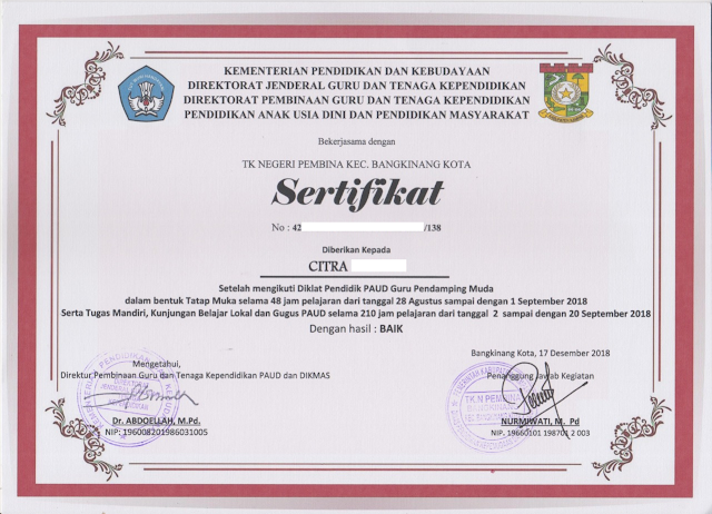
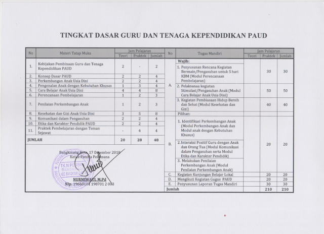
1. Sertifikat Diklat Pendidik PAUD Guru Pendamping Muda 
Berikut ini adalah Sertifikat Diklat Pendidik PAUD Guru Pendamping Muda :

Sertifikat Diklat Pendidik PAUD Guru Pendamping Muda

Sertifikat Diklat Pendidik PAUD Guru Pendamping Muda


Kenapa admin merekomendasikan Sertifikat ini, dikarenakan setelah dilakukan pengamatan di beberapa lembaga Pendidikan PAUD dan PNF di Kecamaatan kami, 7 dari 10 Pendidik ataupun Tenaga Kependidikan memiliki Sertifikat Diklat  Pendidik PAUD Guru Pendamping Muda. Oleh karena itu, admin merekomendasikan Sertifikat ini sebagai salah satu dokumen yang harus di unggah pada Persyaratan Khusus Sertifikat Kompetensi Pendidik. 


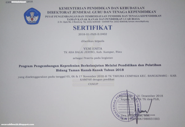
2. Sertifikat Diklat Pengembangan Keprofesian Berkelanjutan (PKB) Bidang Taman Kanak-kanak

Berikut ini adalah Sertifikat Diklat Pengembagangan Keprofesian Berkelanjutan (PKB) Bdiang Taman Kanak-kanak:

Sertifikat Diklat Pengembagangan Keprofesian Berkelanjutan (PKB) Bdiang Taman Kanak-kanak

Sertifikat Diklat PKB juga sangat di rekomendasikan untuk diunggah pada Persyaratan Khusus Sertifikat Kompetensi Pendidik, meskipun belum tau pasti seluruh Pendidik/Tenaga Kependidikan memiliki Sertifikat ini. 


Semoga dua dari Sertifikat yang telah admin jelaskan diatas, rekan sekalian memiliki salah satunya atau dua sekaligus malahan lebih baik. 
Baca Juga : Contoh Format Surat Permohonan Akreditasi PAUD dan PNF
Baca Juga : Dokumen-dokumen Panduan Pelaksanaan untuk Akreditasi PAUD dan PNF di SISPENA 2.0


Demikianlah informasi yang dapat admin bagikan, semoga bermanfaat buat rekan semuanya. Salam semangat dan salam satu data. 


Contoh Desain Spanduk Perpisahan Sekolah SD/MI, SMP/MTs, SMA Keren

April 29, 2019 Add Comment
Contoh Desain Spanduk Acara Perpisahan dan Pelepasan (Paturay Tineung) SD/MI, SMP/MTs, SMK/SMA -  Kali ini Saya akan share contoh desain spanduk yang cocok banget buat acara pelepasan kelas 6 SD, kelas 9SMP/MTs atau kelas 12 SMA. Setiap akhir tahun ajaran semua sekolah pasti selalu mengadakan acara pelepasan/perpisahan putra-putrinya baik itu di sekolah melalui acara seremonial resmi dan diluar sekolah sekaligus acara hiburan.

Pembuatan spanduk atau banner pelepasan sudah menjadi kebiasaan ketika menghadapi acara perpisahan, bahkan sangat diperlukan sehingga nuansa perpisahan akan lebih terasa dan tidak asal-asalan. Masa anak didik yang sudah mengenyam pendidikan selama 3 tahun di sekolah dengan segala macam kenangan yang dilaluinya baik kenangan yang indah maupun menjengkelkan akan dilepas begitu saja bagaikan burung didalam sangkar. Maka mempersiapkan acara perpisahan salah satunya dengan membuat spanduk yang keren akan membuat mereka lebih bahagia dan diperhatikan oleh sekolah.

Sangat penting sekali, bahwa membuat spanduk dengan tema perpisahan (Paturay Tineung) di sekolah harus dibuat dengan desain yang bagus, cocok dengan tema perpisahan anak-anak, tidak monoton dan tentunya selalu mengedepankan estetikanya.

Banyak sekali contoh-contoh desain spanduk acara perpisahan di sekolah yang dibuat menarik dan keren yang tentunya menjadi inspirasi bagi siapa saja yang ingin membuatnya. Nah kali ini Saya akan share salah satu contoh desain spanduk acara perpisahan/pelepasan di sekolah.

Desain spanduk/banner perpisahan sekolah ini Saya buat dengan CorelDraw X7 dengan ukuran 6 x 2,5 meter sesuai dengan ukuran panggung. Ok cek dibawah ini:

Contoh Desain Spanduk Perpisahan Sekolah SD/MI, SMP/MTs, SMA Keren
Desain Spanduk Perpisahan
Scbelum mengunduh coba cek dulu CorelDraw versi yang sudah terinstall di komputer sobat. Yaitu harus menggunakan CorelDraw X7 keatas. File tersebut bisa sobat edit sesuai kebutuhan desain mulai dari font, warna spanduk, ukuran spanduk, dan lainnya.

Berikut ini dokumentasi spanduk acara perpisahan kelas IX SMP yang baru saja dilaksanakan di sekolah.

Jasa Desain Spanduk, Banner, Logo, Brosur, dll

Anda sedang mencari jasa pembuatan desain spanduk dan lainnya, silahkan bisa menggunakan jasa yang kami sebagai admin blog cariduit-dot. Desain yang kami buat terdiri dari:
1. Spanduk apapun
2. Banner
3. Brosur
4. Logo
5. Kartu Undangan, dll.

Untuk harga dan kontak silahkan bisa menghubungi 0852.2022.4879. Desain dibuat semaksimal mungkin tidak asal-asalan demi menjaga kualitas. Tenang saja, melalui jasa kami harga sangat bersahabat.

Demikian Contoh Desain Spanduk Acara Perpisahan dan Pelepasan (Paturay Tineung) SD/MI, SMP/MTs, SMK/SMA semoga bermanfaat. Jika ada yang perlu ditanyakan silahkan komen dikolom komentar dibawah.

Parasite Case of the Week 542

April 29, 2019 Add Comment
This week's case is a lovely gif image compiled by our excellent parasitology technical specialist, Heather Arguello. The following structures were seen on a non-nutrient agar culture that had been inoculated with corneal scrapings. The plate had been overlain with Escherichia coli to provide a food source for parasites that may be present in the specimen. The central structure is ~40 micrometers in maximum dimension, while the rounded structure to the left is ~15 micrometers in diameter. Identification?

Class 10th NCERT Social Science Geography Lifelines of National economy

Class 10th NCERT Social Science Geography Lifelines of National economy

April 29, 2019 Add Comment

Very Short Answers Question

    1. Why do we need transportation?
      • Goods and services do not move from their supply locations to demand locations on their own. The movement of these goods and services necessitates the need for transport.
    2. Why is an efficient means of transport considered as a pre-requisite for fast development?
      • The pace of development of a country depends upon the production of goods and services as well as their movement over space. Therefore, an efficient means of transport is a pre-requisite for fast development.
    3. How are transport, communication and trade complimentary to each other?
      • For a long time, trade and transport were restricted to a limited space. Today the world has been converted into a large village with the help of efficient and fast moving transport. Transport has been able to achieve this with the help of equally developed communication system.
    4. What has contributed to the socio-economic progress of India?
      • Today, India is well linked with the rest of the world despite its vast size, diversity and linguistic and socio-cultural plurality. Railways, airways, waterways, newspaper, radio, television, cinema, internet, etc., have been contributing to its socio-economic progress in many ways.
    5. Classify roads on the basis of their capacity.
      1. North-South Corridors
      2. East-west Corridors
      3. Golden Quadrilateral
      4. National Highways
      5. State Highways
      6. District Roads
      7. Rural Roads
      8. Border Roads
    6. What is the extent of North-South Corridor of India?
      • North-South Corridor links Srinagar (Jammu and Kashmir) to Kanyakumari (Tamil Nadu).
    7. Name the southern terminal station of the ‘North-South Corridor.’
      • Kanyakumari
    8. Name the river which is related to ‘National Waterways’ No. 1.
      • Ganga
    9. How is East-West Corridor connected?
      • East-West Corridor is connecting Silchar (Assam) in the East to Porbandar (Gujarat) in the west.
    10. What do you know about Golden Quadrilateral?
      • The government has launched a major road development project linking Delhi-Kolkata, ChennaiMumbai and Delhi by six lane super highway. It is looked after by National Highway Authority of India.
    11. Who looks after the National Highways of India?
      1. National highways link extreme parts of the country. These are the primary road systems and are laid and maintained by Central Public Works Department (CPWD).
    12. What do you know about National Highway 1?
      1. The historical Sher Shah Suri Marg is called National Highway 1. It is located between Delhi and Amritsar.
    13. Which places are linked by National Highway 2 and 3?
      1. National Highway 2 links Delhi to Kolkata and National Highway 3 links Gwalior to Jhansi.
    14. What do you know about National Highway 7?
      1. National Highway 7 is the longest and traverses 2369 kms between Varanasi and Kanyakumari via Jabalpur, Nagpur, Hyderabad, Bangalore and Madurai.
    15. How is Mumbai and Delhi connected by road?
      1. Delhi and Mumbai is well connected by National Highway 8.
    16. What do you know about National Highway 15?
      1. National Highway 15 covers most of the Rajasthan.
    17. Who looks after State Highways of India?
      1. State Highways are constructed and maintained by the State Public Works Department (PWD) in states and union territories.
    18. Name the river related to National Waterways No. 2
      1. The river related to National Waterway No.2 is River ‘Brahmaputra’.
    19. What do you know about District Roads?
      1. District Roads connect the district headquarters with other places of the district. These roads are maintained by Zila Parishad.
    20. What is ‘Pradhan Mantri Gram Sadak Yojana’?
      1. Rural roads connecting villages to the towns received special impetus under Pradhan Mantri Gram Sadak Yojana. Under this scheme, special provisions are made so that every village in the country is linked to a major town in the country by all season motorable road.
    21. What do you know about Border Roads Organisation?
      1. Border Roads Organisation is a Government of India undertaking which constructs and maintains roads of the bordering areas of the country. This organization was established in 1960 for the development of the roads of strategic importance in the northern and north eastern border areas.
    22. Classify roads on the basis of type of material used in them?
      1. Metalled Roads—May be made of cement, concrete or even bitumen of coal, therefore, they are all weather roads.
      2. Unmetalled roads—Are Kuccha roads, mostly used in rural areas and go out of use in the rainy season.
    23. What does ‘Road Density’ mean?
      1. The length of road per 100 sq. kms of area is known as density of roads.
    24. What is the status of road density in India?
      1. Distribution of roads is not uniform in the country. Density of all roads varies from only 10 kms. in Jammu and Kashmir to 375 kms in Kerala with National Average of 75 km (1996-97).
    25. Why is railways considered a principal mode of transport in India.
      1. Railways are the principal mode of transportation for freight and passengers in India. Railway also make it possible to conduct multifarious activities like business, sightseeing, pilgrimage along with transportation of goods over longer distances.
    26. When was the first train in India launched?
      1. The first train steamed off from Mumbai to Thane in 1853, covering a distance of 34 kms.
    27. What is the network of railways in northern plains?
      1. The northern plains with their vast level land, high population density and rich agricultural resources provided the most favourable condition for their growth.
    28. What is the status of railways in hilly tracts?
      1. In the hilly terrains of peninsular region, railway tracts are laid through low hills, gaps or tunnels.
    29. How are Konkan railways materialised?
      1. In recent times, the development of the Konkan railway along the west coast has facilitated the movement of passengers and goods in this most important economic region of India. It has also faced a number of problems such as sinking of track in some stretches and landslides.
    30. What is a new arrival on the transportation map of India?
      1. Pipeline transport network is a new arrival on the transportation map of India to transport liquids as well as solids in slurry form.
    31. What is the significance of waterways?
      1. Waterways are the cheapest means of transportation. They are the most suitable transportation system for carrying heavy and bulky goods. It is fuel efficient and environment friendly mode of transport.
    32. Where are National Waterway 1 and 2 located?
      1. The Ganga river between Allahabad and Haldia is National Waterway 1.
      2. The Brahmaputra river between Sadiya and Dhubri is National Waterway 2.
    33. Where is National Waterway 3 located?
      1. The West-Coast Canal in Kerala (Kottapuram—Kollam, Udyogamandal and Champakara canals) forms the National Waterway 3.
    34. How many ports do we have in India?
      1. With a long coastline of 7516.6 kms, India is dotted with 12 major and 181 medium and minor ports.
    35. Name the first sea port developed after independence on the western coast of India.
      1. First Sea Port developed after independence –Kandla
    36. Write about the port developed in place of Karachi port, which has gone to Pakistan.
      1. Kandla in Kutch was the first port developed soon after the independence to ease the volume of trade on the Mumbai port in the wake of loss of Karachi port to Pakistan after partition.
    37. What are the benefits of Kandla port today?
      1. Kandla is a tidal port. It caters to the convenient handling of exports and imports of highly productive granary and industrial belt stretching across the states of Jammu and Kashmir, Himachal Pradesh, Punjab, Haryana, Rajasthan and Gujarat.
    38. What is the contribution of two ports of Mumbai?
      1. Mumbai is the biggest port with a spacious natural and well-sheltered harbors. The Jawaharlal Nehru Port was planned with a view to decongest the Mumbai Port and serve as a hub port for this region.
    39. What is the role of Goa port to Economy of India?
      1. Marmagao Port of Goa is the premier iron ore exporting port of the country. This port accounts for about 50% of India’s iron-ore exports.
    40. Name the State related to National Waterways No. 3.
      1. State related to National Waterways No. 3 is Kerala.
    41. Name the port and state which caters to the export of Iron-ore of Kudremukh river.
      1. New Mangalore Port in Karnataka.
    42. Where is Kochi port located?
      1. Kochi is the extreme South-Western Port, located at the entrance of a lagoon with a natural harbor in Kerala.
    43. Which is the oldest artificial Port of India?
      1. Chennai is one of the oldest artificial port of the country. It is ranked next to the one in Mumbai in terms of the volume of trade and cargo.
    44. Which is the deepest landlocked port of India?
      1. Vishakhapatnam is the deepest landlocked and well protected port. This port was originally conceived as an outlet for iron-ore exports.
    45. Which is the Inland port of India?
      1. Kolkata is an inland river port. This port serves a very large and rich hinterland of Ganga-Brahmaputra basin.
    46. What role does Pawanhans Helicopter Ltd. play?
      1. Pawanhans Helicopter Ltd. provides helicopter service to Oil and Natural Gas Commission in its off shore operations to inaccessible areas and difficult terrains like the North-Eastern States and the interior parts of Jammu & Kashmir, Himachal Pradesh and Uttaranchal.
    47. Name the Sea ports of Eastern Coast in descending order.
      1. Haldia and Kolkata Ports
      2. Vishakhapatnam Port
      3. Chennai Port
      4. Tuticorin Port
    48. Name the Sea ports of Western Coast in descending order.
      1. Kochi Port
      2. New Mangalore Port
      3. Marmagao
      4. Mumbai and Jawaharlal Nehru Ports
      5. Kandla Port
    49. Write the name of the international airport of Mumbai.
      1. International Airport of Mumbai-Chhatarpati Shivaji Airport.
    50. What do you know about Indian postal network?
      1. The Indian postal network is the largest in the world. It handles parcels as well as personal letters or written communication.
    51. What is the status of telecom network of India?
      1. India has one of the largest telecom networks in Asia. Excluding urban places, more than two thirds of the villages in India have already been covered with Subscriber Trunk Dialing (STD) telephone facility. There is a uniform rate of STD facilities all over India.
    52. How are telecommunication facilities able to reach remote areas of India?
      1. It has been made possible by integrating the development in space technology with communication technology.
    53. What does ‘Mass Communication’ mean?
      1. Mass communication provides entertainment and creates awareness among people about various national programmes and policies.
    54. What does Mass communication include?
      1. It includes radio,television, newspapers, magazines, books and films. All India Radio (Akashvani) broadcasts a variety of programmes in national, regional and local languages for various categories of people spread over different parts of the country.
    55. What is the role of Doordarshan in mass communication?
      1. Doordarshan, the national television channel of India, is one of the largest terrestrial networks in the world. It broadcasts a variety of programmes from entertainment, educational and sports, etc., for people of different age groups.
    56. What kind of newspapers and periodicals are published in India?
      1. India publishes a large number of newspapers and periodicals annually. Newspapers are published in about 100 languages and dialects. The largest number of newspapers published in the country are in Hindi, followed by English and Urdu
    57. What do you mean by ‘trade’?
      1. The exchange of goods among people, states and countries is referred to as trade.
    58. What is ‘International Trade’?
      1. Trade between two or more countries is called International Trade
    59. What does ‘balance of trade’ mean?
      1. The balance of trade of a country is the difference between its exports and imports.
    60. What is favourable balance of trade?
      1. When the value of exports exceeds the value of imports, it is called a favourable balance of trade.
    61. What does unfavourable balance of trade mean?
      1. If the value of imports exceeds the value of exports, it is termed as unfavourable balance of trade.
    62. Is it true that India’s trade has been superseded by Information and Technology?
      1. India has emerged as a software giant at the international level and it is earning large foreign exchange through the export of information technology.
    63. How many people visit India as foreign tourists?
      1. 5.78 million foreign tourists visited India in 2010. Tourism in India has grown substantially over the last three decades. Foreign tourist’s arrivals in the country witnessed an increase of 11.8 per cent during the year 2010 as against the year 2009, contributing Rs 64,889 crore of foreign exchange in 2010.
    64. What are the benefits of tourism?
      1. Tourism promotes national integration, provides support to local handicrafts and cultural pursuits. It also helps in the development of international understanding about our culture heritage.
    65. What types of tourisms attract tourists to India?
      1. Heritage tourism
      2. Ecotourism
      3. Adventure tourism
      4. Cultural tourism
      5. Medical tourism
      6. Business tourism
    66. Which states are important destinations of foreign tourists?
      1. Rajasthan, Goa, Jammu and Kashmir and temple towns attract foreign tourists in India.
    67. Handling of exports and imports on a large scale is done conveniently from the Kandla port. Why?
      1. Kandla is a tidal port, hence large ship can enter and leave the port easily.
    68. Which commodities are imported by India?
      1. Commodities imported to India are petroleum and petroleum products, pearls and precious stones, inorganic chemicals, coal, coke and briquettes, fertilisers, cereals, edible oils and newsprint.

Short Answers Question

    1. ‘‘Tourism industry in India has grown substantially over the last three decades.’’ Support the statement.
      1. Tourism industry in India has grown substantially over the last three decades
        1. Foreign tourism arrival in the country had seen an increase contributing Rs 21,828 crore of foreign exchange.
        2. More than 15 million people are directly engaged in tourism industry.
        3. Over 2.6 million foreign tourists visit India every year.
        4. Tourism also promotes national integration and provides support to local handicrafts.
    2. ‘‘The advancement of international trade of a country is an index of its economic development.’’ Justify the statement.
      1. ‘The advancement of international trade of a country is an index of its economic development :
        1. It is considered as the economic barometer of a country.
        2. As the resources are space bound, no country can survive without international trade.
        3. A favourable balance of trade of a country indicates economic development.
        4. International trade helps in exchange of surplus goods with those of deficit countries.
        5. Exchange of commodities and goods have been superseded by the exchange of information and knowledge.
    3. What are the problems faced by the Indian railways?
      • The Indian railways faces the following problems:
      1. Many passengers travel without tickets.
      2. Thefts and damage of railway property has not yet stopped completely.
      3. People stop the trains and pull the chain unnecessarily. This causes heavy damage to the railways.
    4. What are the three important networks of pipeline transportation?
      1. From oilfield in upper Assam to Kanpur via Guwahati, Barauni and Allahabad.
      2. From Salaya in Gujarat to Jalandhar in Punjab via Viramgam, Mathura, Delhi and Sonipat.
      3. Gas pipeline from Hazira in Gujarat connects Jagdishpur in Uttar Pradesh via Vijaipur in Madhya Pradesh.
    5. What are the advantages of waterways?
      1. Waterways are the cheapest means of transport.
      2. They are most suitable for carrying heavy and bulky goods.
      3. They are fuel-efficient and also environment-friendly mode of transport.
    6. How does India account for the largest telecom network in India?
      1. More than two-thirds of the villages in India have already been covered with the Subscriber Trunk Dialling (STD) telephone facility.
      2. In order to strengthen the flow of information from the grassroot to the higher level, the government has made special provision to extend twenty-four hours STD facility to every village in the country.
      3. There is a uniform rate of STD facilities all over India.
      4. It has been made possible by integrating the development in space technology with communication technology.
    7. What are the advantages of using pipelines?
      1. Pipelines are used for transporting crude oil, petroleum products and natural gas from oil and natural gas fields to refineries, fertilizer factories and big thermal plants.
      2. Solids can also be transported through pipelines when converted into slurry.
      3. Initial cost of laying a pipeline is high but subsequent running costs are minimal. It rules out transhipment loses or delays.
    8. What is pipeline transportation? Write two merits and demerits of the same.
      1. Pipeline transport network is the new mode of transport these days. In the past, pipelines were used to transport water to cities and industries. Now, these are used for transporting crude oil, petroleum products and natural gas from oil and natural gas fields to refineries,fertilizer factories and big thermal power plants. Solids can also be transported through a pipeline when converted into slurry.
      • Merits:
        1. Useful in transporting liquids and solid slurry from far away locations.
        2. Subsequent running costs after laying down the network are minimal.
        3. It rules out trans-shipment losses or delays.
      • Demerits:
        1. Initial cost of laying pipelines is high.
        2. Pipelines can burst or can have leakage leading to wastage of valuable resource like water, mineral oil, etc.
    9. Why is air travel economical in north-eastern regions?
      1. Airways can cover very difficult terrains like high mountains, dreary deserts, dense forests and long oceanic stretches with great ease.
      2. North-eastern part of the country is marked with the presence of big rivers, dissected reliefs, dense forests and frequent showers and floods and international frontiers, etc.
      3. Air travel has made access easier to these undulating north-eastern states of India.
    10. Give three advantages of personal communication.
      1. It keeps you in touch with your near and dear ones.
      2. Long distance communication is also easier without physical movement of the communicator or receiver.
      3. It helps in integrating families.
    11. Differentiate between personal and mass communication.
      1. Personal CommunicationMass Communication
        1. It’s the communication between person to person.
        It’s the communication among masses.
        2. It provides necessary communication between two people making man a social animal.
        It provides entertainment as well as creates awareness among the masses.
        3. We have letters, e-mails, SMSs, telephone and mobile phone facilities which also include STD and ISD services.
        It includes radio, television, newspapers, magazines, books, films, etc.
    12. Which three highways are included in Super Highways of India?
      1. Golden Quadrilateral: The government of India has launched a major road development project linking Delhi, Kolkata, Chennai, Mumbai and Delhi by a six-lane super highway.
      2. The North-South Corridor: In the north, it links Srinagar of Jammu & Kashmir to Kanyakumari in Tamil Nadu.
      3. The East-West Corridor: It connects Silchar of Assam in the east to Porbandar of Gujarat in the west.
    13. What are the major objectives of these Super Highways?
      1. The major objective of these Super Highways is to reduce the time and distance between mega cities of India. These projects have also helped in the economic development of the country. These highway projects are being implemented by the National Highway Authority of India (NHAI).
    14. What is the strategic importance of New Mangalore and Kochi ports?
      1. New Mangalore: This port is located in Karnataka and caters to the export of iron ore concentrates from Kudremukh mines.
      2. Kochi: Kochi is the extreme South-Western port, located at the entrance of a lagoon with a natural harbour. This port is having the biggest ship building yard.
    15. What kind of port is Port of Tuticorin?
      1. Moving along the east coast, we can see the extreme South Eastern Port of Tuticorin. This port has a natural harbour and rich hinterland. It has a flourishing trade handlings of a large variety of cargoes to even our neighbouring countries like Sri Lanka, Maldives, etc. and the coastal regions of India.
    16. Name the major international airports of India.
      1. Delhi: Indira Gandhi International Airport
      2. Amritsar: Raja Sansi International Airport
      3. Kolkata: Netaji Subhash Chandra Bose International Airport
      4. Mumbai: Chhatrapati Shivaji International Airport
      5. Chennai: Meenambakkam International Airport
      6. Thiruvananthapuram: Nedimbacherry International Airport.
    17. What is India’s status in the making of feature films?
      1. India is the largest producer of feature films in the world. It produces short films, video feature films and video short films. The Central Board of Film Certification is the authority to certify both Indian and foreign films.
    18. What commodities are exported by India?
      1. Commodities exported from India are: agriculture and allied products, ores and minerals, gems and jewellery, chemical and allied products, engineering goods and petroleum products. India has emerged as a ‘software giant’ at the international level and it is earning foreign exchange through the export of information technology.
    19. Why do the movement of goods and services from one place to another require fast and efficient means of transport ? Explain with examples.
      1. Requirement of efficient means of transport:
        1. We use different materials and services in our daily life. Some of these are available in our immediate surroundings, while other requirements are met by bringing things from other places.
        2. Goods and services do not move from supply locales to demand locales on their own. The movement of these goods and services from their supply locations to demand locations necessitates the need for transport.
        3. The products come to the consumers by transportation.
        4. The pace of development of a country depends upon the production of goods and services as well as their movement over space.
    20. Evaluate any three features of ‘Golden Quadrilateral’ Super Highways.
      • Three features of Golden quadrilateral Super Highways:
      • It is the government project of major road development linking Delhi, Kolkata, Chennai, Mumbai and Delhi.
      • It is six lane super highways.
      • It has the objective to reduce the time and distance between the mega cities of India.
      • It is implemented by the NHAI for quick and comfortable movement of goods and passengers in India.
    21. “Information and Communication technology has played a major role in spreading out production of services across countries.” Justify the statement with examples.
      1. Technology stimulated the globalization process:
        1. Improved transportation technology has made much faster delivery of goods across long distance at lower cost.
        2. Goods are placed in the containers that can be loaded intact onto ships, railways, planes and trucks.
        3. Technology in the areas of telecommunication, computers, and internet has been changing rapidly.
        4. Telecommunication facilities are used to contact one another around the world.
    22. “Airways is the most preferred mode of transport in North-Eastern states of India.” Give three reasons to prove this preference. OR  Why is air travel more popular in the North-Eastern states of India? Explain.
      • Air travel is more popular in the north eastern states of India because:
      1. The north-eastern part of the country is marked with the presence of big rivers, dissected relief and dense forests hence, it is difficult to construct roads and railway lines there.
      2. There are frequent floods and international frontiers, which require immediate and quick attention from the government authorities. Floods also damage roads and railway lines.
      3. Air travel has made access to north-eastern part of the country easier and quicker.
Long Answers Question
    1. Examine with example the role of means of transport and communication in making our life prosperous and comfortable.
      1. Role of means of transport and communication :
        Efficient means of transport are pre requisites for fast development.
        1. Today the world has been converted into a large village with the help of efficient and fast moving transport.
        2. We can proudly say that India is well linked with the rest of the world despite its large size.
        3. Railways, Airways, Waterways, Newspapers , Radio , Television , Cinema and Internet etc have been contributing to the socio-economic progress in many ways.
        4. The trades from local to international levels have added to the vitality of its economy.
        5. It has enriched our lives and added substantially to growth and comfort.
    2. What are the various means of mass communication used in India?
      1. It includes radio, television, newspapers, magazines, books and films.
      2. All India Radio broadcasts a variety of programmes in national, regional or local languages.
      3. Doordarshan, the national television channel of India broadcasts a variety of programmes ranging from entertainment, education to sports, etc.
      4. India publishes a large number of newspapers and periodicals annually.
      5. Newspapers are published in about 100 languages and dialects.
      6. India is the largest producer of feature films in the world.It produces short films, video feature films and video short films.
    3. What is the importance of Indian railways? OR  State any four merits of railways.
      1. Railways is the principal mode of transportation for freight and passengers in India.
      2. Railways also makes it possible to conduct a number of activities like business, sightseeing, pilgrimage along with transportation of goods over long distances.
      3. Apart from being a means of transport, the Indian railways has been a great integrating force for more than 150 years.
      4. Railways in India binds the economic life of the country by developing industry and agriculture through transportation. The Indian railways is the largest public sector undertaking in India.
    4. Classify roads of India on the basis of their capacity.
      1. Golden Quadrilateral Super Highways: These projects are implemented by the National Highway Authority of India (NHAI). There are three major Super Highways. Golden Quadrilateral starts from Delhi, moves to Mumbai, Chennai, Kolkata and back to Delhi. The North-South Corridor starts from Srinagar to Kanyakumari. The East-West Corridor connects Silchar to Porbandar.
      2. National Highways: These roads are laid and maintained by Central Public Works Department (CPWD). A number of major National Highways run in North-South and East-West directions, e.g., Sher Shah Suri Marg is called National Highway No. 1.
      3. State Highways: Roads linking a state capital with different district headquarters are known as state highways. These roads are constructed and maintained by States and Union Territories.
      4. District Roads: These roads connect the district headquarters with other places of the district. These roads are maintained by the Zila Parishad.
      5. Rural Roads: These roads link rural areas and villages with towns. These roads are constructed under the Pradhan Mantri Grameen Sadak Yojana.
    5. What do you know about Kandla Port?
      1. Kandla in Kachchh was the first port developed soon after Independence to ease the volume of trade on the Mumbai port. It is the only important port of Gujarat as after partition, the Karachi port had become a part of Pakistan. It is a tidal port. It caters to the convenient handling of exports and imports of highly productive granary and industrial belt stretching across the states of Jammu & Kashmir, Himachal Pradesh, Punjab, Haryana, Rajasthan and Gujarat.
    6. What is the contribution of Mumbai and Goa ports in the economy of India?
      1. Mumbai is the biggest port with a spacious, natural and well-sheltered harbor. The Jawaharlal Nehru port was planned with a view to decongest the Mumbai port and serve as a hub port for this region.
        Marmagao port of Goa is the premier iron ore exporting port of the country. This port accounts for about fifty per cent of India’s iron ore export.
    7. What is the role played by the Eastern coastal ports of India in trade?
      1. Chennai: It is one of the oldest artificial ports of the country. It is ranked next to Mumbai in terms of volume of trade and cargo.
      2. Vishakhapatnam: It is the deepest land-locked and well-protected port. This port was originally conceived as an outlet for iron ore exports.
      3. Paradip Port: It is located in Odisha and specialises in the export of iron ore.
      4. Kolkata: It is an inland riverine port. This port serves a very large and rich hinterland of Ganga-Brahmaputra basin. Being a tidal port, it requires constant dredging of Hoogly.
      5. Haldia Port: It was developed as a subsidiary port, in order to relieve growing pressure on the Kolkata port.
    8. What are the advantages of airways?
      1. Today, air travel is the fastest, most comfortable and the prestigious mode of transport.
      2. It can cover very difficult terrains like high mountains, dreary deserts, dense forests and also long oceanic stretches with great ease.
      3. In north-eastern part of India, there are big rivers, dissected relief, dense forests and frequent floods and international frontiers.In such situations, air transport is considered to be the best option. Government of India has made special provisions to make air travel pocket friendly to north-eastern states of India.
    9. Which tourisms attract foreigners to India?
      1. Foreign tourists visit India for heritage tourism, ecotourism, adventure tourism, cultural tourism, medical tourism and business tourism. Agra (UP), Rajasthan, Goa, Jammu & Kashmir and temple towns of South India are important destinations of foreign tourists. There is a vast potential of tourism development in the north-eastern states and the interior parts of Himalayas, but due to strategic reasons, these have not been encouraged so far. However, there lies a bright future ahead for this upcoming industry.
    10. Compare and contrast the merits and demerits of Roadways with those of Railways.
      1. Roadways v/s Railways
        1. Construction cost of roads is much lower than that of railway lines and construction time is also comparatively less.
        2. Roads can traverse comparatively more dissected and undulating topography which is a limitation in case of railways.
        3. Roads can negotiate higher gradients of slopes and as such can traverse mountains like the Himalayas, whereas the mountainous regions are unfavourable for the construction of railway lines due to high relief, sparse population and lack of economic opportunities. Likewise, it is difficult to lay railway lines on the sandy plains in the deserts, swampy or forested tracks.
        4. Road transport is economical in transportation of few persons and relatively smaller amount of goods over short distances whereas railways are suitable for transportation of large number of people and goods in bulk, especially over long distances.
        5. Roadways provide door-to-door service, thus the cost of loading and unloading is much lower but railways have not reached everywhere, still there are places which are yet to be connected with the railways.
        6. Road transport is also used as a feeder to other modes of transport such as they provide a link between railway stations, air and sea ports. On the other hand, railways work as a life line for the economic growth of a country as they carry raw materials and produced goods from one part of the nation to another on a large scale.
    11. What is trade? Explain the importance of international trade.
      1. Trade: The exchange of goods among people, states and countries is referred to as trade.
        Importance:
        1. International trade of a country is an index to its economic prosperity.
        2. It is considered the economic barometer for a country.
        3. As the resources are space bound, no country can survive without international trade.
        4. Countries have trade relations with the major trading blocks.
        5. Exchange of commodities and goods have been superseded by the exchange of information and knowledge.

    12. ‘Dense and efficient network of transport is a prerequisite for trade.’’ Examine the statement.
      1. Dense and efficient network of transport
        1. They provide trade and connectivity facilities.
        2. Railways, airways, water ways, etc. have been contributing to its socioeconomic progress in many ways.
        3. The trades from local to international levels have added to the vitality of its economy.
        4. It has enriched our lives.
        5. It has added substantially to growing amenities and facilities for the comforts of life.
        6. The world has been converted into a large village with the help of efficient and fast moving transport.
    13. “Roadways still have an edge over railways in India.” Support the statement with arguments. OR  How do roadways score over railways in India?
      1. Roadways still have an edge over railways in India:
        1. Construction cost of roadways is much lower than that of railways. Its maintianance is cheap easy.
        2. Roads can traverse comparatively more dissecting and undulating plains.
        3. Roads can negotiate higher gradients of slopes and can traverse mountains like Himalaya.
        4. Road transport is economical in transportation of few persons and small amount of goods over short distances.
        5. It also provides door to door services.
        6. Cost of loading and unloading is much lower.
        7. Road transport is also used as a feeder to other modes of transport such as they provide link between railway station, airports and sea ports.
        8. It is useful for transport of perishable commodities.
    14. Explain any five major problems faced by road transport in India.
      1. Five major problems faced by road transport in India are:
        1. Keeping in view the volume of traffic and passengers, the road network is inadequate.
        2. About 50% of the roads are unmetalled.
        3. This limits their usage during the rainy season.
        4. The National highways are also inadequate.
        5. Moreover, the roads are highly congested in cities.
        6. Most of the bridges and culverts are old and narrow.

    15. Define the term ‘tourism’. Why is tourism known as a trade? Explain.
      1. The definition of tourism is “The cultural,recreational and commercial visits to places of interest in a country is known as tourism”
        Tourism is known as trade.
        1. Foreign tourist arrivals in the country contributing `64,889/- crore of foreign exchange in 2010.
        2. More than 15 million people are directly engaged in the tourism industry
        3. Tourism provides support to local handicrafts.
        4. Foreign tourists visit India for medical tourism and business tourism.
        5. Helps in the growth of national income and integrity.
HOT 
    1. “Transport routes are called the basic arteries of our economy.” Support this statement with examples.
      1. We use different materials and services in our daily life.
      2. Some of these are available in our immediate surroundings, while other requirements are met by bringing things from other places.
      3. Goods and services do not move from supply locales to demand locales on their own.
      4. The movement of these goods and services from their supply locations to demand locations necessitates the need for transport.
      5. Roads are very significant in carrying goods from one place to another and serve for local, national and international trade.
      6. Railways are the principal mode of transportation for freight and passengers in India. Railways bind the economic life of the country as well as accelerate the development of industry and agriculture.
      7. Pipeline transportation was used for water transportation only. Now these are used for transporting crude oil, petroleum products and natural gas from oil and natural gas fields to refineries, fertiliser factories and big thermal plants.
      8. Waterways are the cheapest mode of transport. They are most suitable for carrying heavy and bulky goods.
      9. Air travel today is the fastest, most comfortable and prestigious mode of transport. Pawan Hans helicopters Ltd. provides helicopter services to oil and natural gas commission in its offshore operations to inaccessible areas and difficult terrains like the North eastern states and interior parts of Jammu and Kashmir, Himachal Pradesh and Uttrakhand.
    2. ‘Transport, communication and trade are complementary to each other’. Explain with two examples.
      1. The pace of development of a country depends upon the production of goods and services as well as their movement over space. Therefore, efficient means of transport is a prerequisite for fast development.
        • For a long time, trade and transport were restricted to a limited space.
        • With the development in science and technology the area of influence of trade and transport expanded far and wide.
        • Today the world has been converted into a large village with the help of efficient and fast moving transport.
        • Transport has been able to achieve this with the help of equally developed communication system.
        • Therefore, transport, communication and trade are complementary to each other.
    3. Why is the distribution of roads not uniform in India? Explain with examples. OR What problems are we facing with roadways in India?
      1. Distribution of roads is not uniform in the country.
        1. Density of all roads varies from only 10 kms in Jammu and Kashmir to 552 kms in UP with national average of 125 kms.
        2. Keeping in view the volume of traffic and passengers, the road network is inadequate.
        3. About half of the roads are unmettled and this limits their usage during the rainy season.
        4. The roadways are highly congested in cities and most of the bridges and culverts are old and narrow.

    4. “The distribution pattern of Indian Railway network is influenced by the physiographic factors.” Examine the statement. OR  How do physiographic, economic and administrative factors influence the railway network in India? OR Analyse the physiographic and economic factors that have influenced the distribution pattern of the railway network in our country. OR Explain with examples the conditions responsible for uneven distribution pattern of the railway network in India.
      1. Physical and economic factors have influenced the distribution pattern of the Indian Railways Network:
        1. Northern Plains : Level land , high population density and rich agricultural resources provided the development of Railways in these plains. However a large number of rivers requiring construction of bridges across their wide banks posed some obstacles .
        2. Peninsular region and the Himalayan region : The railway tracts are laid through low hills , gaps or tunnels .The Himalayan mountainous regions are unfavourable for the construction of railway lines due to high relief , sparse population and lack of economic opportunities .
        3. Desert of Rajasthan:It was difficultto lay railway lines on the sandy plain of western Rajasthan which has hindered the development of railways .
        4. Swamps of Gujarat, forested tracks of Madhya Pradesh, Chattisgarh, Odisha and Jharkhand are also not suitable for the development of railways.
        5. The contiguous stretch of sahyadri could be crossed only through gaps or passes. Although the development of Konkan railway along the west coast has facilitated the movement of passengers and goods in the most important economic region of India. It has also faced a number of problems such as sinking of track in some stretches and landslides.
        6. Peninsular plateau rich in minerals promotes industrial development, encourage the railway tracks.
    5. Describe the measures taken for the quick delivery of mails in cities and large towns. OR  How is classification of mails done by the postal networks of India?
      1. The Indian postal network is the largest in the world. It handles parcels as well as personal written communication.
      2. Cards and envelops are considered first class mail and are airlifted between stations covering both land and air.
      3. To facilitate quick delivery of mails in large town and cities, six main channels have been introduced recently. They are called:
        1. Rajdhani Channel,
        2. Metro Channel,
        3. Green Channel, 
        4. Business Channel,
        5. Bulk Mail Channel &
        6. Periodical Channel.
    6. “No country can survive without international trade in the present Global world.” Explain the statement.
      1. As the resources are space bound, no country can survive without international trade.
      2. Export and import are the components of trade.
      3. International trade helps in exchange of surplus goods with those of deficit countries through foreign trade.
      4. International trade helped India in increasing its productivity and improving quality of its products and then exporting the manufactured goods.
      5. International trade had also helped India to import recent technology to improve its productivity and the quality of the product.
      6. Government’s policy of globalisation and liberalisation had helped four folds in making its place in the Global World.
    7. Why is tourism considered a trade as well as an industry?
      1. Tourism in India has grown substantially over the last three decades.
        1. Foreign tourists’ arrival in the country had seen an increase, contributing ₹ 64,889 crore of foreign exchange.
        2. More than 15 million people are directly engaged in tourism industry.
        3. Tourism also promotes national integration and provides support to local handicrafts.
        4. It also helps in the development of international understanding about Indian culture and heritage.
        5. Foreign tourists visit India for heritage tourism, ecotourism, adventure tourism, cultural tourism, medical tourism and business tourism.
        6. Rajasthan, Agra (UP), Goa, Jammu & Kashmir and temple towns of South India are important destinations of foreign tourists in India.
    8. Means of transportation and communication are called the lifelines of a nation and its economy. Why?  OR   “Efficient means of transport are pre-requisites for the fast development.” Express your views in favour of this statement.
      1. Movement of goods and services from their supply locations to demand locations necessitates the need for transport.
      2. The pace of a country depends upon the production of goods and services as well as their movement over space.
      3. Therefore, efficient means of transport and communication are prerequisites for fast development.
      4. Therefore, modern means of transport and communication serve as lifelines of our nation and its modern economy.
SELF 
    1. Which state has the highest road density?
    2. Which port has been developed to decongest Kolkata Port?
    3. Which port is the biggest with a spacious natural and well-sheltered harbour?
    4. What is the length of coastline of India?
    5. Explain any four merits and two demerits of air transport.
    6. What is Balance of Trade? In which situations is it favourable and unfavourable.
    7. Describe any three features of waterways in India.
    8. Describe the significance of tourism as a trade in India.
    9. Explain the improvements made by Indian Railways in its functioning.
    10. Describe any five points of importance of mass communication.
    11. Explain giving four reasons how tourism as an industry has a bright future in India.
    12. “Advancement of international trade of a country is an index of its economic prosperity”. Justify the statement with five arguments.
    13. Explain why road transport still need to be developed in India. What are the priority areas?
    14. Why are border roads important for us?
    15. Mark the following on the given outline political map of India:
      1. East-West Corridor from Silchar to Porbandar
      2. Two sea ports on the west coast

Important Terms

  • Transportation: The action of transporting someone or something from one place to another.

    1. Consumer: A person who purchases goods and services for personal use.
    2. Communication: The imparting or exchanging of information by speaking, writing, or using some other medium.
    3. Topography: The arrangement of the natural and artificial physical features of an area.
    4. Super Highways: A highway designed for travel at high speeds, having more than one lane for each direction of traffic, a safety strip dividing the two directions, and cloverleaves to route the traffic on and off the highway.
    5. Sea Ports: A port harbour, or town accessible to a seacoast and providing accommodation for seagoing vessels.
    6. Tourism: The commercial organization and operation of holidays and visits to places of interest.
    7. State Highways are usually roads that link important cities, towns and district headquarters within the state and connect them with National Highways or highways of neighbouring states.
    8. National Highways: Network of India is a network of highways that is managed and maintained by agencies of the Government of India.
    9. A Border Road Organisation (BRO) develops and maintains road networks in India’s border areas and friendly neighbouring countries.
    10. Railway Network: Rail transport is a means of conveyance to passengers and goods on wheeled vehicles running on rails, also known as tracks. It is also commonly referred to as train transport.
    11. Trade: The action of buying and selling goods and services.