Showing posts with label underground. Show all posts

Air Defense and Combat Command HQ

October 15, 2019 Add Comment

Situated in the town of Chunghwa, south of Pyongyang, North Korea's air force headquarters is located at the "Air Defense and Combat Command" (from here on abbreviated KPAF HQ). From here, over 110,000 personnel, 1,700 aircraft, and 37 key bases (along with less important ones) are overseen by a headquarter complex that is nestled within a range of low hills.

Little is directly known about the complex, but based on Landsat/Copernicus satellite imagery, we can determine that the headquarters has been in this location since at least 1984. Unfortunately, the image resolution is very low but you can still make out lighter colored man-made structures against the darker, tree covered hills.


North Korea's air force, the Korean People's Air Force (KPAF) is divided into six primary combat, training, and transport divisions.

  • 1st Air Combat Division (headquartered at Kaechon)
  • 2nd Air Combat Division (headquartered at Toksan)
  • 3rd Air Combat Division (headquartered at Hwangju and is responsible for the DMZ)
  • 5th Air Transport Division (headquartered at Taechon)
  • 6th Air Transport Division (headquartered at Sondok)
  • 8th Air Training Division (headquartered at Orang/Hoemun-ri, is also responsible for defense of the northeastern part of the country)

Within the divisions include associated forces like airborne (which has at least seven training bases) and reconnaissance. The KPAF has also had a drone (UAV) program since the 1970s.
The use of drones continue to be of concern to South Korean and Allied forces, particularity after multiple sightings of North Korean UAVs and incursions into the DMZ and ROK airspace. Small UAVs flying at under 500 feet are capable of avoiding most radar and air defense systems, leaving South Korea vulnerable to the asymmetric capabilities that UAVs bring to the battle space.

The first clear look at KPAF HQ comes from imagery dated November 2006. (Click on any image for a larger view.)


The eastern quadrant of the base holds storage bunkers and a possible underground entrance. There is also an old hardened artillery site just outside of the base's perimeter.


Between 2012 and 2013 a new building was constructed next to the Juche Study Hall. It's likely a gymnasium due to the recreational sports fields next to it. A crisp image of the building can be seen on October 26, 2015.


Since 2006, thirteen buildings have been constructed within the complex.


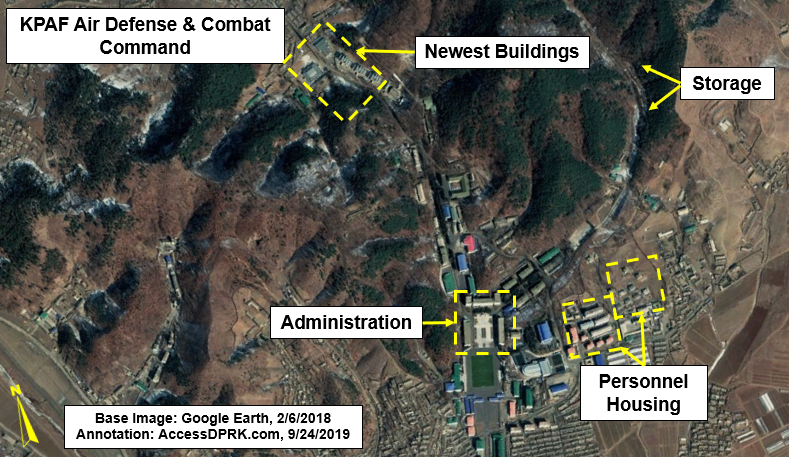
Construction of the newest buildings began in 2017. They lie at the rear of the base (due north), and include three, three-story residential buildings, a possible new assembly building, and another large building with an unidentified purpose. These buildings are in the same area as an underground entrance which itself saw construction work in 2011.


The underground site could be part of building an underground command center but there's no real way to know what the current purpose of it is or its status.

The regime has been placing a lot of effort into modernizing their conventional forces as well as their nuclear program. Today's KPAF HQ is a much different place than it was in 2006, with most of the changes happening under Kim Jong Un.


Despite having a dated air fleet, Pyongyang is creating indigenous air defense systems, they are working on ways to avoid sanctions on fuel, and they are trying to computerize as much as possible. This means that a modern headquarters is needed to oversee an adequate defense structure while also maintaining their abilities to carry out offensive war plans should they determine the time has come.


I want to give a quick shout out to my Patreon supporters: Kbechs87, GreatPoppo, and Planefag.

--Jacob Bogle, 10/14/2019
Patreon.com/accessdprk
www.JacobBogle.com
Facebook.com/JacobBogle
Twitter.com/JacobBogle

Work at the Hagap Underground Facility Continues

September 01, 2019 Add Comment
Hagap is a large underground facility that lies right across the provincial border in Chagang Province, near the International Friendship Exhibition (in North Pyongan Province).

Landsat/Copernicus satellite imagery shows that Hagap was constructed in 1991 (although it seems the US intelligence community didn't learn about it until 1996). By 1998, within the public sphere, Hagap was suspected of being one of North Korea's centrifuge facilities and was often mentioned in the same breath as the site at Kumchang-ni. At the time, the Defense Intelligence Agency said, "There is one site, of an unconfirmed function, that possibly could be a nuclear-weapons-related facility by 2003...The function of this site has not been determined, but it could be intended as a nuclear production and/or storage site."

Changes at the Hagap site are visible between the 1990 and 1991 images.

Hagap, as with Kumchang-ni, seems to never have been completed and certainly never became a functioning nuclear site. But questions started being raised about Hagap, specifically, despite the initial insistence by the Pentagon that it was a nuclear site. These questions were made more relevant by the fact that, after being inspected by an international team, Hagap didn't appear large enough or well suited to house a nuclear reactor or serve other related purposes.

As mentioned earlier, Hapag is near the International Friendship Exhibition, a mere 5 km away. This and other reasons (some I mentioned above) has led to some analysts calling into question its nuclear purpose. The other idea is that it's actually being turned into a massive records storage complex; Pyongyang's answer to Iron Mountain.


In 2017 I first reported on new work being conducted at both Hagap and at the IFE. The construction at both sites seems to have begun in 2016 and continues to this day. Before I get into the alternative purpose for Hagap, I want to go over these ongoing changes.


The above image shows the site as it appeared in October 2013 and after work had resumed in October 2016, after many years of apparent inactivity. The main difference is a large pile of excavated debris.


Aside from the pile of excavated material, additional areas of activity could also be seen around the site.


By 2019 what the "other activity" was turning into became clear.


The large pile of rock was in fact debris from tunneling operations to create a new entrance to the site that would allow vehicles inside. The other activity was the construction of a road that led into the facility.


The new entrance site is very clear on this April 10, 2019 image.

Access to Hagap is a small access road that comes off the Pyongyang-Huichon Highway. There is no obvious security gate or fence system that surrounds the complex. This leads me to suspect that it isn't an important nuclear-related facility. While there are coincidences in timing between construction periods at Hagap and construction periods at known nuclear sites, that's about the only similarity.

And even as a weapon's storage site, Hagap seems to be ill fitted. For one, having a central storage site for your most important weapons isn't a good idea. A major strike could wipe them all out. Secondly, Hagap is at least 50 km away from the nearest suspected ballistic missile base. Moving weapons to there from Hagap, up and down winding, unpaved roads, would leave them vulnerable to observation and attack for extended periods of time.

The other two suspected nuclear sites, Kumchang-ni (in North Pyongan Province) and Yeongjeo-ri (in Ryanggang Province) are both positioned far into a closed valley and cover large areas. They have support buildings spread throughout and have perimeter security. The same can be said for nearly all of North Korea's ballistic missile sites. And while Yongbyon isn't hidden, it is surrounded by air defense and has multiple security fences and checkpoints. Hagap doesn't have any of these things, and though it is tucked away in a valley, it only takes up a relatively small footprint, plus it's just a mile off the main highway and doesn't appear to have any military units on-site to provide protection.

Hagap does have housing but they're not typical "harmonica houses" or in barrack form (both styles dominate military housing). They're small apartment blocks next to what may be administrative buildings. And finally, work has been taken to "beautify" the area with tree-lined roads, ponds, and a lovely central building at the main entrance. On the other hand, Yongbyon looks like any factory town and the uranium plants at Pakchon and Pyongsan are plain industrial sites. Only the Kim's are worthy of a forested campus.


Whether Hagap was envisioned to be a nuclear or research facility that was later re-purposed into an archival facility or whether it was always supposed to be an Iron Mountain we may never know, but the site's rural location and it being underground mean that anything inside would be likely to survive even the most catastrophic of wars or rebellion. And with all of the "gifts" being transported to the IFE, Hagap is nearby to receive more serious cargo. After three generations, Kim Jong Un is having to save the country his grandfather created. He must also ensure that the history of the country (both official and real histories) is saved. Hagap looks to be the perfect place for that.


I'd like to thank my supporters on Patreon: Kbechs87, GreatPoppo, and Planefag.

--Jacob Bogle 9/1/2019
Patreon.com/accessdprk
www.JacobBogle.com
Facebook.com/JacobBogle
Twitter.com/JacobBogle

The Evolution of Kim's Underground Airbase

May 14, 2019 Add Comment

There are 20 air bases and one heliport with underground facilities within North Korea, however, one of those air bases stands out from the rest. While the others simply have maintenance taxiways that take aircraft away from the main runway and to underground facilities for their maintenance, resupply, and general protection, the air base at Kangda-ri (near Anbyon) actually has a runway that goes completely through a mountain. It is one of only two of its kind in the country (the other being Onchon, S. Pyongyang).

Kangda-ri has existed since at least 1984 based on Landsat images. At the time, it was just a simple dirt runway with the mountain some 500 meters off to the east. Basic work on the secondary runway which goes through the mountain appears to have began around 1997-98. Work soon stalled but was restarted in 2000. Additional work occurred in 2009-2010 and since then, almost nothing. However, imagery from late 2018 shows that new work has commenced.

1984 satellite image of Kangda-ri. The small dirt runway is barely identifiable as a thin line running parallel to the river.

By 1998, clear evidence of tunneling work under the mountain can be seen.

By 2001, the main tunnel through the mountain has been cut and the runway is beginning to extend out both sides of the mountain.

Imagery from 2002 is of high enough resolution to show detailed construction work.


This image shows two main features. First, that blast doors were installed. These will, theoretically, protect the tunnel from attack. The second is that the tunnel employs a very clever but simple design: having two ceilings. The first ceiling is simply the exposed stone of the tunnel, the second is a separate concrete arch. This "tunnel within a tunnel" acts as a shield and protects whatever is inside the tunnel from debris and small collapses of the outer stone tunnel should the mountain be bombed. This type of design was employed by the Nazis to protect key naval and missile facilities and has been used by other nations, like the US in the construction of Cheyenne Mountain.

The original runway was then upgraded in 2009-10 to a larger paved runway.


The original runway was approx. 5,400 feet long and 70 feet wide. The upgraded runway that was completed in 2010 is substantially larger at approx. 8,200 feet long and 145 feet wide.

Construction work on a bridge and road to connect the two runways actually began sometime before 2007 but was never completed. Additionally, it seems that this larger runway was abandoned as it has been overgrown and repeatedly flooded. Minor activity of various kinds can be seen between 2010 and 2017 at the underground site, but no further substantial work happened until 2018.


By 2018 several changes could be seen. 1) the pile of spoils (debris) from tunneling work has grown; 2) the southern section of runway has been resurfaced; and 3) there is an extension protruding to the west off of the northern section of runway.


The current dimensions of the extension is approx. 455 feet long and between 75 and 105 feet wide (depending on the section measured). There's no way to know what it's for at this point and based on the mind-numbing slow pace of work here, we may not know for a very long time, if the place is ever even finished. However, the fact the regime has continued to expend resources here across two generations of leadership shows that the site retains some level of importance.

The exact purpose of Kangda-ri is unknown, although we do know that it is part of the 2nd Air Combat Division (HQ at Toksan).
According to Joshua Stanton over at Free Korea, the underground runway is both too short and not wide enough for fighter jets. But, the Anbyon region is suspected to hold a major chemical weapons storage facility, so perhaps the smaller runway is supposed to be part of loading and transport. Smaller aircraft can then be lined up and taxi to the main runway (should the bridge ever be completed) where they can take the weapons to any other part of the country when needed. At this point, it's all conjecture.


--Jacob Bogle, 5/14/2019
www.JacobBogle.com
Facebook.com/JacobBogle
Twitter.com/JacobBogle

NK's Construction Boom Continues

May 17, 2018 Add Comment
As I noted with Pyongyang, North Korea has embarked on a multi-billion dollar construction campaign since Kim Jong Un assumed power in December 2011. From new and improved airports, to expansive tourist developments, and more, the construction boom is continuing apace.

While most of the attention is given to Pyongyang and Wonsan, the large east coast city of Hamhung is receiving its fair share of upgrades. Current changes include hundreds of new housing units, a new orphanage, and the complete reconstruction of an underground complex. Other projects completed since 2011 include a new rocket engine test facility, a water park, and additional housing throughout the city.

Click on any image for an enlarged view.

There have been three large sets of family housing constructed between 2015 and 2017. The yellow area was constructed from 2015-2016, the two blue areas in 2016, and the red between 2016 and 2017.


Additionally, Hamhung now has its own version of Pyongyang's Mirae Street - new large apartment blocks and tall buildings lining a major road. For Hamhung, they're located across from the National Science Academy on Jongsong Street. The initial planning for part of these apartment blocks began sometime before 2007, as foundation excavation can be seen, but the project stalled and construction didn't resume until 2010. The southern half of the project didn't get its start until 2015, and the whole row of buildings weren't completed until late 2017-early 2018.


New orphanages, nurseries, and retirement facilities have been constructed in many of the largest cities in the country, with Hamhung recently completing its new orphanage and nursery.


The nursery also has 8 small sets of solar panels. Some are in the yard and others are on the roof.


Based on historical Landsat imagery, this underground complex and its associated external buildings were constructed around 2003. Beginning in 2016, major renovations and reconstruction could be seen. The different buildings are in various stages of work.


Hamhung has a long history of playing a role in North Korea's nuclear, chemical, and biological weapons programs. Undoubtedly such a large underground facility is part of a major research program. Unfortunately, I have not been able to positively identify the site. If you know what purpose it serves, please leave a comment or contact me directly!


Here is a close-up of the Hamhung water park that was constructed in 2013. Since coming to power, Kim Jong Un has devoted a large amount of resources to constructing leisure facilities like water parks, amusement parks, ski resorts, and upgrading open spaces and athletic facilities.


Finally, located less than 2 miles (2.8 km) down the coast from the "No. 17 Explosives Factory" in southern Hamhung, is the Magunpo Rocket Engine Test Facility. Construction of the site began in 2013 and was completed by the end of 2014-early 2015. The focus of the facility is to test solid propellants, and the last test occurred in October 2017.


--Jacob Bogle, 5/17/2018
www.JacobBogle.com
Facebook.com/JacobBogle
Twitter.com/JacobBogle

Kim Jong-un's Secret Escape Plan

May 23, 2017 Add Comment
Pyongyang has one of the deepest subway systems in the world. It dives as much as 360 feet (110 meters) beneath the earth. And like many subways in national capitals, there are rumors of secret train lines that stand ready to spirit the country's elite to safety in the event of war or revolt. North Korea applied much of what it learned from the Soviet Union when it comes to protecting the leadership: from secret subway lines, to tunnels that run for miles connecting various palaces and government buildings, and even an alleged one that extends all the way to China!

There are special runways, helipads, and train stations that allow the Kims to travel the country in luxury and safety (and without having to wait in line for hours like the average peasant). These "No. 1" train stations are well known and easily identifiable, and even the special runways can be found with little effort (including the new ones that keep popping up), but it can be difficult to find tunnels via satellite. It's even more difficult to verify the rumors about secret underground escape routes.

There is an arc of natural hills that lie north of downtown Pyongyang, and each of them is covered with military bases, intelligence buildings, artillery sites, etc., but one of them is special. Located next to the Ministry of Armed Forces District, a hardened, partially underground heliport reveals itself. Its exact coordinates are 39.0633°, 125.7336°, and since I haven't seen any (ANY) information about it, I thought it would be a good idea to share what I know.


It's within a mile of four known metro stations, adjacent to the West Pyongyang Train Station, and near a main arterial highway. You can use all three modes of transportation to rapidly go from Pyongyang's secured government quarter to the Military District. And if there are secret tunnel connections, Kim Jong-un could make the trip without fear of being blown up. It's also only 4 miles (6.4 km) away from the newly modernized elite heliport which is used by Kim and the regime's top dogs, and 10 miles (16 km) south of Pyongyang Int'l Airport (which doubles as the home of North Korea's version of Air Force One).

This secret "get out" heliport is not directly connected to the Military District above ground. In fact, a multilayered fence divides the two areas, however, a tunnel exits near a villa that goes into the hill and could theoretically connect the two areas, which are less than 500 meters apart.

Google Earth/DigitalGlobe image clearly showing the tunnel entrance and villa. Dated May 7, 2013.

Based on satellite imagery, the heliport and associated buildings was under construction in June 2000 and was completed by November 2000.

Here is a Google Earth image from June 12, 2000 showing the construction process.


This one shows the completed work on Nov. 5, 2000.


The area surrounding the heliport also underwent drastic changes over a number of years. Below is an image of the area on Nov. 5, 2000.


After several years of work, the area had been completely changed. Most of the work was completed by the end of 2006.


More recent activity was seen in 2013, when one of the hardened hangars was demolished following what appears to have been a collapse. The apparent collapse occurred at the start of 2013 and the cleanup work seems to have been completed by the end of the year.


While helicopters haven't been seen in any public access satellite images, the protective hangar doors have been seen opened in several images. One such time was May 10, 2016.


In September 2016, what looks to be the scorch marks from a fire or explosion can be seen on the left landing pad. On the Google Earth image dated Aug. 27, 2016, an unidentified object or mound of material can be seen on the landing pad. By the Sept. 23 image, a large blackened area can be seen, indicative of a fire or explosion.


While I don't know if the object/mound in the first image is actually related to the explosion, the fact it was there soon before is worth mentioning. The burnt area hasn't been repaired as of April 22, 2017.

Trying to figure out where Kim Jong-un could go without knowing what kind of helicopters are available here is a bit of a guessing game, but if we assume they're one of the known helicopter types North Korea has (such as the Mi-8 Hip, or Mi-2 Hoplite), he could easily reach 270-300 miles (434-482 km) before needing to refuel. That range places nearly every other airport, palace, and key military base in North Korea within reach. It would also enable an emergency flight to China.

What exactly goes on at this site or where Kim Jong-un could ultimately end up if he had to flee can only be a matter of speculation (for now), but it's obvious the regime has taken great steps over the years toward protecting itself.


--Jacob Bogle, May 24, 2017
JacobBogle.com
Facebook.com/JacobBogle
Twitter.com/JacobBogle

Additional Reading
1. Report: US has mapped North Korean underground escape facilities (Aug. 5, 2015, Stars and Stripes)

Activity Spotted at Possible Nuclear Site

January 12, 2017 Add Comment
There's a massive underground complex hidden away in the hills of North Korea. For years it has laid dormant (as far as one can tell), that is until recently. The facility at Hagap (40° 04′ 48″ N, 126° 10′ 56″ E), is a suspected underground nuclear site, either to store material or produce it.

According to Dr. Jeffery Lewis, at Armscontrolwonk.com, the site became publicly known in 1998 (the US government knew about it since 1996) and was constructed at the same time as another underground site, Kumchangni (40° 7' 8 "N 125° 8' 32"E). Since such a site could possibly violate the bilateral 1994 Agreed Framework, North Korea didn't say a word about the place. After the site became public, the US managed to send a delegation to visit it. They didn't find much besides an oddly designed underground facility.

The debate about what exactly is going on at Hagap continues to this day. It has been speculated that the site is used for nuclear materials storage, centrifuge production, or even just a large secure warehouse for archival materials. However, the connection with Kumchangni still remains. There is a third site too, at Yeongjeo-ri (Ryanggang Province), but little is known about it.

North Korea's nuclear program has been ramping up since the final days of Kim Jong-il, and Kim Jong Un seems to be increasing that pace. In the light of that, it is disconcerting to see fairly substantial new activity happening at Hagap.

(Click image for larger view.)

At the site you can see a large mound of new rock debris which has been piled up in the pond below the main entrance. You can also see an increase in the number of small buildings and debris that are in the small valley.

Here are some closeup images:

This one shows the debris mound.

This image shows the extended activity area with new buildings.

There is also an odd collection of towers nearby. They look like electrical transmission pylons, but are clustered together into three groups. There are no visible power lines either. It's possible these were laid out when Hagap was originally constructed to provide power, but haven't been needed since the site was largely abandoned. Or they could be some kind of radar/communication array. The towers are located around a bend in a river with small hills on either side, those hills have an anti-aircraft artillery battery stationed on each one. If you'd like to study the area further, it can be found here  40° 4' 50"N 126° 6' 35"E.


--Jacob Bogle, 1/12/2016
JacobBogle.com
Facebook.com/JacobBogle
Twitter.com/JacobBogle