Hagap is a large underground facility that lies right across the provincial border in Chagang Province, near the International Friendship Exhibition (in North Pyongan Province).
Landsat/Copernicus satellite imagery shows that Hagap was constructed in 1991 (although it seems the US intelligence community didn't learn about it until 1996). By 1998, within the public sphere, Hagap was suspected of being one of North Korea's centrifuge facilities and was often mentioned in the same breath as the site at Kumchang-ni. At the time, the Defense Intelligence Agency said, "There is one site, of an unconfirmed function, that possibly could be a nuclear-weapons-related facility by 2003...The function of this site has not been determined, but it could be intended as a nuclear production and/or storage site."

Hagap, as with Kumchang-ni, seems to never have been completed and certainly never became a functioning nuclear site. But questions started being raised about Hagap, specifically, despite the initial insistence by the Pentagon that it was a nuclear site. These questions were made more relevant by the fact that, after being inspected by an international team, Hagap didn't appear large enough or well suited to house a nuclear reactor or serve other related purposes.
As mentioned earlier, Hapag is near the International Friendship Exhibition, a mere 5 km away. This and other reasons (some I mentioned above) has led to some analysts calling into question its nuclear purpose. The other idea is that it's actually being turned into a massive records storage complex; Pyongyang's answer to Iron Mountain.

In 2017 I first reported on new work being conducted at both Hagap and at the IFE. The construction at both sites seems to have begun in 2016 and continues to this day. Before I get into the alternative purpose for Hagap, I want to go over these ongoing changes.

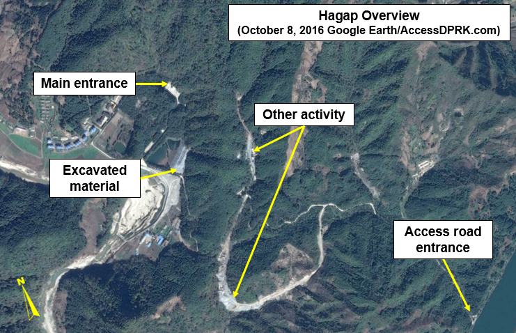
The above image shows the site as it appeared in October 2013 and after work had resumed in October 2016, after many years of apparent inactivity. The main difference is a large pile of excavated debris.

Aside from the pile of excavated material, additional areas of activity could also be seen around the site.

By 2019 what the "other activity" was turning into became clear.

The large pile of rock was in fact debris from tunneling operations to create a new entrance to the site that would allow vehicles inside. The other activity was the construction of a road that led into the facility.

The new entrance site is very clear on this April 10, 2019 image.
Access to Hagap is a small access road that comes off the Pyongyang-Huichon Highway. There is no obvious security gate or fence system that surrounds the complex. This leads me to suspect that it isn't an important nuclear-related facility. While there are coincidences in timing between construction periods at Hagap and construction periods at known nuclear sites, that's about the only similarity.
And even as a weapon's storage site, Hagap seems to be ill fitted. For one, having a central storage site for your most important weapons isn't a good idea. A major strike could wipe them all out. Secondly, Hagap is at least 50 km away from the nearest suspected ballistic missile base. Moving weapons to there from Hagap, up and down winding, unpaved roads, would leave them vulnerable to observation and attack for extended periods of time.
The other two suspected nuclear sites, Kumchang-ni (in North Pyongan Province) and Yeongjeo-ri (in Ryanggang Province) are both positioned far into a closed valley and cover large areas. They have support buildings spread throughout and have perimeter security. The same can be said for nearly all of North Korea's ballistic missile sites. And while Yongbyon isn't hidden, it is surrounded by air defense and has multiple security fences and checkpoints. Hagap doesn't have any of these things, and though it is tucked away in a valley, it only takes up a relatively small footprint, plus it's just a mile off the main highway and doesn't appear to have any military units on-site to provide protection.
Hagap does have housing but they're not typical "harmonica houses" or in barrack form (both styles dominate military housing). They're small apartment blocks next to what may be administrative buildings. And finally, work has been taken to "beautify" the area with tree-lined roads, ponds, and a lovely central building at the main entrance. On the other hand, Yongbyon looks like any factory town and the uranium plants at Pakchon and Pyongsan are plain industrial sites. Only the Kim's are worthy of a forested campus.
Whether Hagap was envisioned to be a nuclear or research facility that was later re-purposed into an archival facility or whether it was always supposed to be an Iron Mountain we may never know, but the site's rural location and it being underground mean that anything inside would be likely to survive even the most catastrophic of wars or rebellion. And with all of the "gifts" being transported to the IFE, Hagap is nearby to receive more serious cargo. After three generations, Kim Jong Un is having to save the country his grandfather created. He must also ensure that the history of the country (both official and real histories) is saved. Hagap looks to be the perfect place for that.
I'd like to thank my supporters on Patreon: Kbechs87, GreatPoppo, and Planefag.
--Jacob Bogle 9/1/2019
Patreon.com/accessdprk
www.JacobBogle.com
Facebook.com/JacobBogle
Twitter.com/JacobBogle
Landsat/Copernicus satellite imagery shows that Hagap was constructed in 1991 (although it seems the US intelligence community didn't learn about it until 1996). By 1998, within the public sphere, Hagap was suspected of being one of North Korea's centrifuge facilities and was often mentioned in the same breath as the site at Kumchang-ni. At the time, the Defense Intelligence Agency said, "There is one site, of an unconfirmed function, that possibly could be a nuclear-weapons-related facility by 2003...The function of this site has not been determined, but it could be intended as a nuclear production and/or storage site."

Changes at the Hagap site are visible between the 1990 and 1991 images.
Hagap, as with Kumchang-ni, seems to never have been completed and certainly never became a functioning nuclear site. But questions started being raised about Hagap, specifically, despite the initial insistence by the Pentagon that it was a nuclear site. These questions were made more relevant by the fact that, after being inspected by an international team, Hagap didn't appear large enough or well suited to house a nuclear reactor or serve other related purposes.
As mentioned earlier, Hapag is near the International Friendship Exhibition, a mere 5 km away. This and other reasons (some I mentioned above) has led to some analysts calling into question its nuclear purpose. The other idea is that it's actually being turned into a massive records storage complex; Pyongyang's answer to Iron Mountain.

In 2017 I first reported on new work being conducted at both Hagap and at the IFE. The construction at both sites seems to have begun in 2016 and continues to this day. Before I get into the alternative purpose for Hagap, I want to go over these ongoing changes.

The above image shows the site as it appeared in October 2013 and after work had resumed in October 2016, after many years of apparent inactivity. The main difference is a large pile of excavated debris.

Aside from the pile of excavated material, additional areas of activity could also be seen around the site.
By 2019 what the "other activity" was turning into became clear.

The large pile of rock was in fact debris from tunneling operations to create a new entrance to the site that would allow vehicles inside. The other activity was the construction of a road that led into the facility.

The new entrance site is very clear on this April 10, 2019 image.
Access to Hagap is a small access road that comes off the Pyongyang-Huichon Highway. There is no obvious security gate or fence system that surrounds the complex. This leads me to suspect that it isn't an important nuclear-related facility. While there are coincidences in timing between construction periods at Hagap and construction periods at known nuclear sites, that's about the only similarity.
And even as a weapon's storage site, Hagap seems to be ill fitted. For one, having a central storage site for your most important weapons isn't a good idea. A major strike could wipe them all out. Secondly, Hagap is at least 50 km away from the nearest suspected ballistic missile base. Moving weapons to there from Hagap, up and down winding, unpaved roads, would leave them vulnerable to observation and attack for extended periods of time.
The other two suspected nuclear sites, Kumchang-ni (in North Pyongan Province) and Yeongjeo-ri (in Ryanggang Province) are both positioned far into a closed valley and cover large areas. They have support buildings spread throughout and have perimeter security. The same can be said for nearly all of North Korea's ballistic missile sites. And while Yongbyon isn't hidden, it is surrounded by air defense and has multiple security fences and checkpoints. Hagap doesn't have any of these things, and though it is tucked away in a valley, it only takes up a relatively small footprint, plus it's just a mile off the main highway and doesn't appear to have any military units on-site to provide protection.
Hagap does have housing but they're not typical "harmonica houses" or in barrack form (both styles dominate military housing). They're small apartment blocks next to what may be administrative buildings. And finally, work has been taken to "beautify" the area with tree-lined roads, ponds, and a lovely central building at the main entrance. On the other hand, Yongbyon looks like any factory town and the uranium plants at Pakchon and Pyongsan are plain industrial sites. Only the Kim's are worthy of a forested campus.
Whether Hagap was envisioned to be a nuclear or research facility that was later re-purposed into an archival facility or whether it was always supposed to be an Iron Mountain we may never know, but the site's rural location and it being underground mean that anything inside would be likely to survive even the most catastrophic of wars or rebellion. And with all of the "gifts" being transported to the IFE, Hagap is nearby to receive more serious cargo. After three generations, Kim Jong Un is having to save the country his grandfather created. He must also ensure that the history of the country (both official and real histories) is saved. Hagap looks to be the perfect place for that.
I'd like to thank my supporters on Patreon: Kbechs87, GreatPoppo, and Planefag.
--Jacob Bogle 9/1/2019
Patreon.com/accessdprk
www.JacobBogle.com
Facebook.com/JacobBogle
Twitter.com/JacobBogle


