Showing posts with label Chunghwa. Show all posts

Air Defense and Combat Command HQ

October 15, 2019 Add Comment

Situated in the town of Chunghwa, south of Pyongyang, North Korea's air force headquarters is located at the "Air Defense and Combat Command" (from here on abbreviated KPAF HQ). From here, over 110,000 personnel, 1,700 aircraft, and 37 key bases (along with less important ones) are overseen by a headquarter complex that is nestled within a range of low hills.

Little is directly known about the complex, but based on Landsat/Copernicus satellite imagery, we can determine that the headquarters has been in this location since at least 1984. Unfortunately, the image resolution is very low but you can still make out lighter colored man-made structures against the darker, tree covered hills.


North Korea's air force, the Korean People's Air Force (KPAF) is divided into six primary combat, training, and transport divisions.

  • 1st Air Combat Division (headquartered at Kaechon)
  • 2nd Air Combat Division (headquartered at Toksan)
  • 3rd Air Combat Division (headquartered at Hwangju and is responsible for the DMZ)
  • 5th Air Transport Division (headquartered at Taechon)
  • 6th Air Transport Division (headquartered at Sondok)
  • 8th Air Training Division (headquartered at Orang/Hoemun-ri, is also responsible for defense of the northeastern part of the country)

Within the divisions include associated forces like airborne (which has at least seven training bases) and reconnaissance. The KPAF has also had a drone (UAV) program since the 1970s.
The use of drones continue to be of concern to South Korean and Allied forces, particularity after multiple sightings of North Korean UAVs and incursions into the DMZ and ROK airspace. Small UAVs flying at under 500 feet are capable of avoiding most radar and air defense systems, leaving South Korea vulnerable to the asymmetric capabilities that UAVs bring to the battle space.

The first clear look at KPAF HQ comes from imagery dated November 2006. (Click on any image for a larger view.)


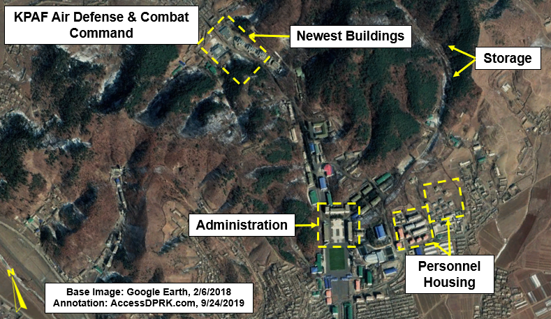
The eastern quadrant of the base holds storage bunkers and a possible underground entrance. There is also an old hardened artillery site just outside of the base's perimeter.


Between 2012 and 2013 a new building was constructed next to the Juche Study Hall. It's likely a gymnasium due to the recreational sports fields next to it. A crisp image of the building can be seen on October 26, 2015.


Since 2006, thirteen buildings have been constructed within the complex.


Construction of the newest buildings began in 2017. They lie at the rear of the base (due north), and include three, three-story residential buildings, a possible new assembly building, and another large building with an unidentified purpose. These buildings are in the same area as an underground entrance which itself saw construction work in 2011.


The underground site could be part of building an underground command center but there's no real way to know what the current purpose of it is or its status.

The regime has been placing a lot of effort into modernizing their conventional forces as well as their nuclear program. Today's KPAF HQ is a much different place than it was in 2006, with most of the changes happening under Kim Jong Un.

Despite having a dated air fleet, Pyongyang is creating indigenous air defense systems, they are working on ways to avoid sanctions on fuel, and they are trying to computerize as much as possible. This means that a modern headquarters is needed to oversee an adequate defense structure while also maintaining their abilities to carry out offensive war plans should they determine the time has come.


I want to give a quick shout out to my Patreon supporters: Kbechs87, GreatPoppo, and Planefag.

--Jacob Bogle, 10/14/2019
Patreon.com/accessdprk
www.JacobBogle.com
Facebook.com/JacobBogle
Twitter.com/JacobBogle

North Korea's Air Force & Airports

November 15, 2015 Add Comment
NOTE: Scroll to the bottom to download a Google Earth KMZ file of all airfields and heliports.


Introduction

The Korean People's Army Air Force was created in 1947 and is one of five branches of the Korean People's Army. Today it has around 1,000 aircraft with 110,000 personnel. Given the military primacy system (Songun) of North Korea, we might as well consider domestic and military aviation controls as one and the same.

The KPAAF is currently divided into six divisions: 1st Air Combat Command (HQ at Kaechon), 2nd Air Combat Command (HQ at Toksan), 3rd Air Combat Command (HQ at Hwangju), 5th Air Transport Division (HQ at Taechon), 6th Air Transport Division (HQ at Sondok), and the 8th Air Training Division (HQ at Orang). These are all controlled by the central Air Defense and Combat Command which is headquartered in Chunghwa, Pyongyang.

(As always, click on the pictures to see a larger view.) 


Combat air divisions consist of four to nine air regiments, service and support units, and have approximately 160-300 aircraft.
They are organized into a headquarters and division command post, three to six fighter regiments, one bomber regiment, one to two helicopter regiments, five to seven anti-aircraft rocket brigades (SAM brigades), communications center, radar regiment, nuclear-chemical defense battalion, engineering battalion, transportation battalion, guard battalion, and a maintenance and repair unit.

The overall combat readiness of the air force is low, ranging from 50% to 70%. Due to ongoing fuel shortages and lack of repair equipment/parts, training flight time is usually less than an hour and generally consists of take-off's and landings.

Airfields

The country has a total of 99 airfields and heliports. There are 12 main airfields, these include the six divisional headquarters, Pyongyang International Airport, Wonsan Airport, and others. There are 14 highway strips which are widened lengths of road used to serve as emergency runways in the event of war or other crisis. Of all the airfields, 20 are basic grass landing strips, 33 are paved, and 19 are heliports or single helipads. Ten of the known airstrips that still exist are also either fully abandoned or severely neglected. One thing I find curious, is that Chagang Province only has one airport, at Manpo. Chagang is a key military manufacturing region with otherwise limited infrastructure (it only has two domestic access points by rail).

This shows the locations of all the airfields. The plane icons are for planes, helicopters for heliports, and the divisional headquarters are shown larger.


Improvements

Over the last few years there have been a number of improvements/expansions made to existing airports, and a few new ones have been constructed as well.

Located about 12 miles from the heart of Pyongyang, North Korea's only official international airport (Pyongyang-Sunan International) underwent renovations and the expansion of its terminal.

The following pictures are of the terminal before and after primary construction was over.


Another facility in Pyongyang to undergo improvements was the VIP heliport in downtown. Situated along the bank of the Taedong River and among elite neighborhoods, the original heliport was completely demolished and new one was built next to the old site.

Former heliport
New site

Moving across the country to the east coast city Wonsan, we find North Korea's newest (as of yet unofficial) international airport - Wonsan Airport. With Kim Jong-un's approval, starting in 2013 the airport underwent an extensive remodeling with the intent of enabling the development of a planned "Wonsan-Mount Kumgang Tourist Zone". The airport project is estimated to have cost $200 million. If true, that would represent over 1% of the country's entire economic output. For some perspective, 1% of America's GDP would be $170 billion.

Each year North Korea receives around 100,000 visitors, Wonsan's new capacity is 1.2 million. The original plan for Pyongyang's expansion was to accommodate 12 million!

Here's a side-by-side comparison of the before and after.


There have been two new airports built in the last few years. There's a new Kumgang Airport (which is still not operational) that I wrote about in March 2015, and also in 2015, North Korea built a small paved airfield next to the International Friendship Exhibition.

Here is the unused Kumgang Airport which replaced the grass Kumgang landing strip.


Google Earth File

I have been able to pull from different sources (not to mention the fact I've literally looked at every square mile of North Korea) and was able to put together a Google Earth KMZ file. It contains the locations of all 93 existing current and former airfields/heliports, along with a visual count of all aircraft seen, and additional information/links for certain airfields. To explore the file you will need have Google Earth.

To automatically download the file from my Google site "AccessNorthKorea", just click THIS link.
To check out the site first (not much there yet) you can visit it here. The file name is "AirportsAirbases-updated-12-1-15.kmz".

Further Reading

Korean People's Air Force, Wikipedia article
North Korea Air Bases, Federation of American Scientists
Korean People's Air Force, Wikileaks document


--Jacob Bogle, 11/15/2015
www.JacobBogle.com
Facebook.com.JacobBogle
Twitter.com/JacobBogle