Showing posts with label 2016. Show all posts

Recovery Moves Along After 2016 Floods

April 02, 2017 Add Comment
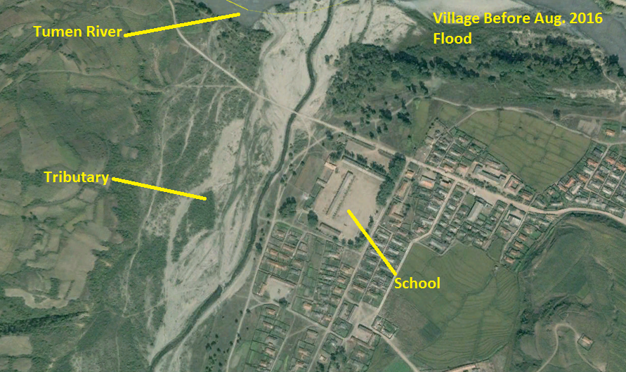
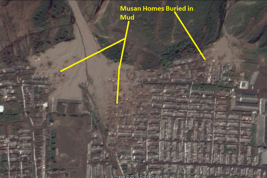
Between August and September 2016, floods ravaged the northern reaches of North Korea. As I wrote about in December, satellite images showed us the devastation caused by these floods which affected over half a million people.

I'd like to now discuss the satellite images showing the recovery process. These images taken on October 25, 2016, focus on the hard-hit city of Hoeryong, North Hamgyong Province.

Image of the flood damage along the river. Google Earth, 9/14/16.

Dyke reconstruction work. Google Earth, 10/25/16.

Reporting coming out of North Korea claim that over a kilometer of dykes has been fully repaired.

In this next image we see new housing being constructed.

Image source: Google Earth, 10/25/16.

This is the DPRK/China border crossing. It received only minor damage, but you can see repair efforts under way as well as trucks coming in from China with relief and construction supplies.
The repair of this border crossing comes after North Korea constructed a new border crossing in Rason (which will be the subject of my next post).

Image source: Google Earth, 10/25/16.

Annual floods cause a fair amount of destruction and death in North Korea, but the northern provinces are often the most badly hit. UNICEF sent aid (including $1 million from the US) to help children and families affected by last year's flood.

-- Jacob Bogle, 4/2/2017
www.JacobBogle.com
Facebook.com/JacobBogle
Twitter.com/JacobBogle - Use the hashtag #AccessDPRK to join the conversation!

Activity Spotted at Possible Nuclear Site

January 12, 2017 Add Comment
There's a massive underground complex hidden away in the hills of North Korea. For years it has laid dormant (as far as one can tell), that is until recently. The facility at Hagap (40° 04′ 48″ N, 126° 10′ 56″ E), is a suspected underground nuclear site, either to store material or produce it.

According to Dr. Jeffery Lewis, at Armscontrolwonk.com, the site became publicly known in 1998 (the US government knew about it since 1996) and was constructed at the same time as another underground site, Kumchangni (40° 7' 8 "N 125° 8' 32"E). Since such a site could possibly violate the bilateral 1994 Agreed Framework, North Korea didn't say a word about the place. After the site became public, the US managed to send a delegation to visit it. They didn't find much besides an oddly designed underground facility.

The debate about what exactly is going on at Hagap continues to this day. It has been speculated that the site is used for nuclear materials storage, centrifuge production, or even just a large secure warehouse for archival materials. However, the connection with Kumchangni still remains. There is a third site too, at Yeongjeo-ri (Ryanggang Province), but little is known about it.

North Korea's nuclear program has been ramping up since the final days of Kim Jong-il, and Kim Jong Un seems to be increasing that pace. In the light of that, it is disconcerting to see fairly substantial new activity happening at Hagap.

(Click image for larger view.)

At the site you can see a large mound of new rock debris which has been piled up in the pond below the main entrance. You can also see an increase in the number of small buildings and debris that are in the small valley.

Here are some closeup images:

This one shows the debris mound.

This image shows the extended activity area with new buildings.

There is also an odd collection of towers nearby. They look like electrical transmission pylons, but are clustered together into three groups. There are no visible power lines either. It's possible these were laid out when Hagap was originally constructed to provide power, but haven't been needed since the site was largely abandoned. Or they could be some kind of radar/communication array. The towers are located around a bend in a river with small hills on either side, those hills have an anti-aircraft artillery battery stationed on each one. If you'd like to study the area further, it can be found here  40° 4' 50"N 126° 6' 35"E.


--Jacob Bogle, 1/12/2016
JacobBogle.com
Facebook.com/JacobBogle
Twitter.com/JacobBogle

New launching/landing sites constructed?

January 06, 2017 Add Comment
UPDATE: These have been confirmed as emergency parking positions for jets, since highways can be used as auxiliary airfields (and North Korea does have at least 14 official "emergency highway strips").


On the heels of Kim Jong-un suggesting that the country is very close to testing another ICBM, I've discovered three sites that could be used as dedicated mobile-missile-launcher pads.

These sites were constructed in 2016 and have the same general design.

The first and largest is near Kaesong and lies less than 10 miles (16 km) from the Demilitarized Zone with South Korea.

Located adjacent to the Pyongyang-Kaesong Highway, by the village of Haeson-ri, this site was under construction in March and had been completed by October 2016.

Each pad is 45 feet (14 meters) wide and the straight portion is 175 feet (53 meters) long. The area around it also contains numerous bunkers and tunnels.

The second site is in Pyongsong, South Pyongan Province, which is 21 miles (34 km) north-northeast of the center of Pyongyang.


Just like the Kaesong site, this one is located adjacent to a main highway. In this case, National Highway 65. The area also has a high concentration of HARTS (Hardened ARTillery Sites), which are marked by the red dots. Several additional military facilities are also nearby.


Lastly, the third site is similar in its size and the fact it's right off a highway, but its design is different. The primary difference is a lack of a central berm. This site is located near Sukchon, also on South Pyongan.


If these are indeed dedicated pads for launching missiles, it would be in line with North Korea's continued modernization and expansion of their offensive capabilities.

________________________________________________________________________________________
I'd like to make a quick note about the #AccessDPRK Mapping Project. Across North Korea, I have located 9,500 military related places. I have finished the primary mapping process and am now working on incorporating the work of two others into a main and comprehensive single file. After that, the entire body of work will be published.

--Jacob Bogle 1/6/2017
www.JacobBogle.com
Facebook.com/JacobBogle
Twitter.com/JacobBogle

Over Half Million Affected by Floods

December 02, 2016 Add Comment
Flooding during monsoon season is an annual problem for North Korea, especially given its mountainous terrain and poor land management practices. Heavy flooding in August is said to have affected some 600,000 people according to North Korea's Red Cross Society. Urgent aid was needed as winter comes early and harsh, particularly for those in northern areas (which also tend to receive less government attention and assistance in general).

Map of Tumen River.

The primary river in the northeast of the country is the Tumen, which flows from Mt. Paektu and forms part the DPRK-China border and near it's mouth, the DPRK-Russia border. The river drains some 5,000 square miles (13,000 sq. km) of rugged and mountainous areas of North Korea.

According to the Korean Central News Agency, reconstruction has now finished in Hoeryong, North Hamgyong Province, including a new kilometer-long dike to protect against further flooding of the Tumen.

Here are some satellite images of the flood damage along the river, including the cities of Hoeryong and Musan. The occassional curvy and thin yellow line is the map border between North Korea and China. Simply click on any picture and you'll be able to see larger versions.

This is a before and after image showing flooding behind the old Tumen River Dike. It shows a new river channel and destroyed buildings.


Here is a picture of one of several portions of road that was washed out along a tributary to the Tumen in the Hoeryong region.

The next two pictures give a before and after view of a Hoeryong neighborhood that was completely destroyed by the floods.


Nearby is the only non-rail bridge that connects that neighborhood to the rest of the city. The flood took out a section of it.

Moving up river, toward Musan, there's a section that shows distinct flood damage. You can see debris and mud built up in the river bed, discoloration of the land where crops were destroyed, and a road that was "smeared" out as the Tumen overflowed its banks.

Here is a small village that was almost completely erased.
Before the flood:

After:

In Musan, the destruction wasn't limited to just a flooded river. Musan is a key mining city and sits in a series of vallies with steep hills and mountains surrounding it, there's a tributary river running through it and then, lastly, the Tumen cuts off the western side.

Here you can see buildings destroyed by the Tumen.

And here are homes that were buried in mud and rocks as otherwise dry ephemeral mountain streams turned into raging torrents.


Finally, the Hoeryong border crossing facility was also severely damaged. At least two of the buildings suffered major damage and the land around the facility was wrecked. In the satellite image you can also see some of the construction equipment as the government tries to clear the area and make repairs.


--JacobBogle, 12/2/2016
www.JacobBogle.com
Facebook.com/JacobBogle
Twitter.com/JacobBogle - Use the hashtag #AccessDPRK to join the conversation!

Manpo-Changchuan Hydroelectric Dam Construction Continues

January 17, 2016 Add Comment
Some 8 miles (13 km) north of Manpo, North Korea, along the Yalu River border with China, a new hydroelectric dam has slowly been growing. It's named for the village of Changchuan, although the North Korean name given is Mun'ak.

Satellite imagery suggests that construction on the dam began sometime around 2013 and has been proceeding from the North Korean side to China; the nearest Chinese city being Ji'an.

You can see the beginning stages of construction in this image from January 5, 2014.


I haven't been able to find much additional information about it. NKEconomyWatch posted that North Korea and China were planning to build two additional hydroelectric dams on the Yalu. One would be built from the Chinese side and the other would come from North Korea.

The North Korean dam, located by the small village of Changchuan, is estimated to cost $78 million and is expected to produce 154 million kWh annually (enough to power 14,000-20,000 homes). The initial agreements to build the dams came in 2004 and 2008, with a proposed completion date of 2013. Obviously, they've fallen behind.

This image from October 21, 2014 shows the work advancing and shows the hydroelectric generating station under construction.


The original width of the Yalu River at this point was around 850 feet (259 m). The latest imagery available, May 24, 2015, shows the dam has pinched the river into a 100 foot (30 m) wide neck. It also shows a cofferdam large enough to facilitate the construction of 4-5 additional "ribs", and that the hydroelectric station's construction is also continuing at pace. The hydroelectric facility has rooms to hold 4 generators.


Here is a picture of the "worker's village". It includes housing, manufacturing buildings, and equipment sheds.

A mile (0.6 km) north of the construction site, they have carved out a quarry on the river bank to use for the cofferdam and, possibly, the concrete used in building the dam. The quarry covers approx. 330,000 sq feet (30,600 sq meters).

It also looks like the dam was originally going to be built 0.8 miles to the north but was moved to its current location for some reason.


The nearest completed dam is the Yunfeng Dam, which is 12 miles (40 km) north and became fully operational in 1967. It has a 400 MW generating capacity. Once this dam is completed it will be the fifth hydroelectric dam on the Yalu.

UPDATE - Aug. 31, 2018
After missing the initial completion deadline, the dam is slated to be completed in 2019. The construction of this and other Yalu River dams is expected to bring in millions of dollars' worth of energy trade with China, something not banned by UN sanctions.

Construction progress as of May 5, 2018.


--Jacob Bogle, 1/17/2016
www.JacobBogle.com
Facebook.com/JacobBogle
Twitter.com/JacobBogle