Showing posts with label ICBM. Show all posts

Missile Bases & Major Underground Sites

October 23, 2019 Add Comment

North Korea is perhaps the most militarized country in history. As a country roughly the size of the US state of Pennsylvania, it has literally thousands of distinct military sites: air defense, training bases, coastal artillery batteries, airbases, missile sites, tunnels, and much more. Because of the country's nuclear program, their missile bases receive a lot of attention. However, there is still a lot that is unknown about these sites, in part, because North Korea has only officially acknowledged a handful of them (and often just in vague terms).

The satellite facilities at Sohae, Tonghae and the Chiha-ri missile base are fairly well known, but the good folks over at Beyond Parallel (part of the Center for Strategic International Studies) estimate there may be as many as 20 undeclared ballistic missile bases and related support facilities. The 2017 release of "Phase II" of the AccessDPRK mapping project listed over 9,500 military points of interest, and since then, I have begun work on the next part of the map which now includes an additional 1,500 military sites. Using this unpublished version, I decided to see what likely missile bases and large underground facilities exist in the country. (These stand-alone underground facilities are something Beyond Parallel isn't looking at.)

After going through every identified military base, tunnel, underground facility (UGF), known and suspected missile base, and other sites, I was able to locate 18 known and possible ballistic missile bases, the two satellite launch stations, and 39 large UGFs that are separate from the missile bases.


North Korea considered the creation of a ballistic missile program soon after the Korean War and it became an official goal as early as 1965, with Kim Il Sung saying the country needed to have rockets that could fire as far as Japan. From then until the early 1980s, the regime laid the foundations of the program including the acquisition of Soviet and Egyptian technology. In 1984 they were able to test their first indigenously produced missile which was a variation of the SCUD-B.

The height of their missile program came with the first internationally verified successful orbital insertion of a satellite into space in 2012, the Kwangmyŏngsŏng-3 Unit 2, followed by the 2017 test of the Hwasong-15 missile which can reach nearly all of the United States.

The vast size of North Korea's missile program infrastructure (dozens of locations in a country the size of Pennsylvania) helps to ensure that they can continue to carry out attacks if one or several bases are destroyed during a war. It also makes it all the more difficult for Western powers to keep track of the movement of weapons and equipment.

North Korea's ballistic missiles and ranges. Image from the Center for Strategic International Studies. 

By 2017 the country was thought to have around 900 short-range missiles, though that figure may have grown to 1,000+ with the apparent development of a North Korea-produced clone of the Russian Iskander missile. (As well as from the continued production of known missile systems.)
Short-range missile are typically defined as having a range of 1,000 km (620 miles) or less. Examples include the KN-02, Hwasong-6, and the aforementioned Iskander clone.
Medium-range missiles have a range of 1,000-3,000 km (620-1,860 mi). Examples include the Rodong-1 and Pukkusong-2 (KN-15). North Korea likely has 500 or fewer of these missiles.
Intermediate-range missiles can reach 3,000-5,500 km (1,864-3,418 mi). An example is the Hwasong-12. There are likely fewer than 250 IRMBs.
ICMBs (intercontinental ballistic missiles) have a range exceeding 5,500 km (3,400 mi). North Korea's Hwasong-15 is their latest developed ICBM. There are probably fewer than 75 operational missiles in this category.

The country's missile bases are divided into three main "belts". They are, with increasing distance away from the DMZ the, "tactical belt", "operational belt", and "strategic belt". The different belts reflect the types of missiles deployed at each base, with the strategic belt holding long-range missiles (this includes the submarine base at Mayang) and the tactical belt being the site of shorter-range missiles aimed at the DMZ, Seoul, and other important South Korean sites.

Pyongyang's missile program is under the control of the Korean People's Army (KPA) Strategic Forces and the construction of the bases is done by KPA Unit No. 583 (the Military Construction Bureau). Substantial construction began for many of the bases in the late 1980s to mid-1990s, and construction at all sites had either already began or was scaled up by the 2000s. Several ballistic missile bases, such as Chiha-ri and Yusang-ni, have had upgrades since Kim Jong Un came to power.


A note on naming. Unless a name has been given in an official North Korean or US-ROK alliance intelligence source, all of the locations talked about in this article are otherwise named for the nearest populated place as listed by OpenStreetMap. A lack of standard naming has led to confusion for years, but that's one thing this article seeks to remedy. And, instead of simply saying "a base in Chagang Province" or "by Kimchon-ni" (when there are multiple villages with the same name), this article will list the base's exact coordinates.

These twenty main facilities occupy approx. 362.5 square kilometers of territory. Despite my best efforts, I wasn't able to positively identify the To'gol base (allegedly in Pyongsan County) or the Kittaeryong base (in Anbyon County).


Within the "tactical belt" are:

1. Chiha-ri - Coordinates are: 38°36'10.63"N 126°44'12.20"E
2. Kal-gol - Coordinates are: 38°40'3.15"N 126°44'49.97"E
3. Kumchon-ni - Coordinates are: 38°57'54.14"N 127°36'8.48"E. Kumchon-ni has been detailed by Beyond Parallel.
4. Sakkanmol - Coordinates are: 38°34'59.81"N 126° 6'29.91"E. Sakkanmol has been detailed by Beyond Parallel.
5. Sing'ye - Coordinates are: 38°38'24.31"N 126°40'48.26"E. Sing'ye is one of the smallest missile bases in the country. It may also be the source name for the Hwansong-class of missiles as a nearby village is named Hwasong, and the base was constructed early on.
6. Suthae-ri - Coordinates are: 38°22'51.67"N 127°29'0.55"E. Suthae-ri is a possible base and hasn't been mentioned in any media that I could find. At less than 10 km from South Korean territory, it would be the closest ballistic missile base to the DMZ. The base doesn't have the "drive thru" bunkers that many other known bases have, but it does have a large and expanding underground facility and several bunkers of other types.

Chiha-ri, Kal-gol, and Sing'ye are all within 5 km of each other, which would lead me to believe that they are connected in some way; perhaps in mutual-supporting roles.

Within the "operational belt" are:

1. Hodo - Coordinates are: 39°24'30.31"N 127°32'5.63"E. The Hodo base is very small and is more for testing missiles than as an operating base during conflict. Hodo seems to have replaced the beaches at Wonsan for testing sort-range missiles, as the site at Wonsan is now a cluster of hotels.
2. Hwajil-li - Coordinates are: 39°11'52.58"N 125°23'56.93"E. Hwajil-li is listed by the Nuclear Threat Initiative as a missile base that was constructed in the 1980s. Current satellite imagery doesn't show anything that would suggest the site is currently used as a missile base. A basic air defense battery and associated facilities is all that exists today.
3. Ongpyong - Coordinates are: 39°19'33.69"N 127°19'50.68"E. It is a smaller base and its facilities may be dispersed throughout a larger area.
4. Singsong-ri - Coordinates are: 39°21'32.23"N 125°45'49.57"E. Singsong-ri is a possible base. Like Suthae-ri, it doesn't fit the design of a lot of other known bases, but it does have three underground entrances which run deep into a mountain. If it is indeed a base, it's likely used to store missiles and equipment.
5. Yusang-ni - Coordinates are: 39°26'51.58"N 126°15'30.33"E. Yusang-ni has been detailed by Beyond Parallel.

On average, the land area used by these bases is smaller than bases in the other two belts.

Within the "strategic belt" are:
This belt includes the country's two satellite launching stations as they have played a role in the development of ballistic missile technology and could be used as launching sites.

1. Hoejung-ni - Coordinates are: 41°22'21.64"N 126°54'46.14"E. Hoejung-ni is one of the newest missile bases to be constructed. It is only a few kilometers from the base at Yeongjo-ri
2. Kusong-ri (alleged) - Coordinates are: 39°59'51.22"N 124°34'16.80"E. According to Jane's/IHS, this surface-to-air missile base also houses some Nodong missiles.
3. Riman-ri (Yongnim) - Coordinates are: 40°29'2.94"N 126°30'1.65"E
4. Sangnam-ri - Coordinates are: 40°50'20.20"N 128°32'35.82"E. Sangnam-ri has been detailed by Beyond Parallel.
5. Sinpo-Mayang - Coordinates are: 39°59'42.09"N 128°11'43.98"E. Sinpo houses part of a large submarine base (the other half being on Mayang Island) and has a missile test stand. The base is where North Korea is developing their submarine launched ballistic missiles.
6. Sino-ri - Coordinates are: 39°38'57.32"N 125°21'36.37"E. Sino-ri has been detailed by Beyond Parallel.
7. Sohae Satellite Launch Center - Coordinates are: 39°40'6.88"N 124°42'30.44"E
8. Taegwan - Coordinates are: 40°18'34.10"N 125°16'17.02"E
9. Tonghae Satellite Launch Center - Coordinates are: 40°52'13.09"N 129°38'34.10"E. My discovery of a missile test stand being constructed at the site was the basis of my very first #AccessDPRK post back in 2013.
10. Yeongjo-ri - Coordinates are: 41°19'44.56"N 127° 5'35.38"E. Once considered a nuclear site, Yeongjo-ri is actually a missile base.

The next area I want to explore is the collection of large underground facilities (UGFs).

As mentioned earlier, these UGFs are not part of any obvious missile base. Underground sites abound in North Korea and serve as active and reserve storage sites for weapons, equipment, food, and other supplies, and they allow for artillery to be fired and then rolled back into the tunnel for protection against counter strike. There has been a lot of speculation about the number of tunnels and underground sites within the country with some estimates going as high as 100,000. Based on the work for AccessDPRK, the real figure is much closer to 1,000 sites (some may have multiple entrances, but they're part of a single facility). Most of them are small and some are used as underground factories. But there are a few dozen (39 to be exact) which are much larger than any of the others (excluding underground industrial sites).


Some of them are placed at military bases and consist of a single complex while others exist as clusters, especially in Pyongyang.

There are four UGFs in Chagang Province.
1. Oil-rodongjagu UGF - 40°59'53.82"N 126°46'51.12"E
2. Janghang UGF - 40°57'32.66"N 126°41'9.98"E
3. Kanggye-Puji UGF - 40°53'12.75"N 126°38'4.45"E
4. Jonchon UGF - 40°32'49.08"N 126°19'48.21"E. This facility is across from the Riman-ri (Yongnim) missile base and so may be connected to it in some way.

There are three UGFs in S. Hamgyong Province.
1. Toksan UGF - 40° 1'52.84"N 127°35'48.28"E
2. Sinphung UGF - 39°58'7.64"N 127°50'17.89"E
3. Songhung UGF - 39°22'54.97"N 127°10'43.71"E

There are five UGFs in Kangwon Province.
1. Chongdu-ri UGF - 38°22'2.71"N 128° 2'20.19"E
2. Wondong-ri UGF - 38°24'51.14"N 127°41'59.76"E
3. Konsol-li UGF - 38°29'30.47"N 127° 0'7.53"E. The UGF here is part of a new military base that was constructed in 2016-2017.
4. Jisang-ri UGF - 38°34'44.13"N 126°44'5.59"E
5. Kubong-ri UGF - 38°37'44.89"N 126°43'15.55"E

There are four UGFs in N. Hwanghae Province.
1. Phyongwon UGF - 38°46'42.16"N 126°27'47.77"E. This has a very large UGF and might actually be part of their missile infrastructure.
2. Taephyong UGF - 38°26'5.60"N 126°20'37.53"E
3. Misan-ri - 38°34'41.50"N 125°56'6.04"E. This is a set of two enormous bunkers.
4. Okhyon - 38°22'4.16"N 125°44'22.81"E

There are 23 UGFs in Pyongyang. Eleven of them are in three clusters. Each cluster will only get one set of coordinates.
1. Pyongyang Group 1 - 39° 5'58.09"N 125°49'48.07"E. There are three large tunnels/entrances that spread out in an east-west line approx. 1 km long.
2. Pyongyang Group 2 - 39°10'11.96"N 125°51'28.16"E. This is a set of five large tunnels that are along a valley between two sets of hills. From the coordinate given, a rectangle is formed by a line running 1.4 km west to east and then from that point, north to south for ~0.5 km.
3. Pyongyang Group 3 - 39° 5'54.07"N 125°57'1.50"E. This is a group of three tunnels that are all located within the same hill, encircling it.
4. Pyongyang Single UGF - 39° 6'43.85"N 125°58'24.30"E
5. Taedonggang Large UGF - 39°10'25.07"N 125°56'43.60"E
6. Taedonggang Smaller UGF - 39°10'31.77"N 125°56'46.76"E
7. Samdung UGF - 39° 1'32.28"N 126°12'56.77"E
8. Rodgon-ri UGF - 38°57'54.22"N 126° 2'27.51"E
9. Sangwon UGF - 38°49'39.49"N 126° 5'23.32"E
10. Chunghwa UGF - 38°52'28.51"N 125°48'23.32"E. This UGF is within the Air Defense & Combat Command HQ complex.
11. Sunwha UGF - 39° 0'52.08"N 125°36'15.03"E
12. Kanchong UGF - 38°51'34.16"N 125°33'15.48"E
13. Kangso 1 - 38°52'55.87"N 125°30'57.91"E
14. Kangso 2 - 38°52'46.98"N 125°31'48.32"E

Here are a few examples of these underground facilities.


Patreon Special Access
Patreon supporters at the $20 tier are entitled to exclusive data sets. The Google Earth file for this post is one of those exclusive offers. This is the only nationwide map of these facilities within the public domain that contain accurate geolocation data and additional information. The file also has over 300 specific sites of interest within the various missile bases for your research pleasure. Please consider supporting me on Patreon and get access to this and other exclusive data sets.

I would like to thank my current Patreon supporters: Kbechs87, GreatPoppo, and Planefag.

--Jacob Bogle, 10/22/2019
Patreon.com/accessdprk
www.JacobBogle.com
Facebook.com/JacobBogle
Twitter.com/JacobBogle

Missiles and Monuments

October 02, 2019 Add Comment
North Korea has been touting itself as a strong, powerful, socialist nation for generations. That propaganda, however, has largely been devoid of reality. That is, until the newest incarnation of the divine Paektu Bloodline arrived to save the people of North Korea. Whatever caricatures may exist of Kim Jong Un being a squat, little "rocket man" with funny hair and whatever very real criticisms exist of the terrible human rights situation in the country, the fact is undeniable: Kim Jong Un has fulfilled the nation's long promoted promise of turning North Korea into a nuclear-armed state with a credible missile deterrent.

While the country has had a missile program for decades, the main propaganda surrounding those developments were limited to posters, songs, and "documentaries", even when progress was made under Kim Il Sung and Kim Jong Il. However, satellite imagery shows that Kim Jong Un feels he deserves something more long lasting, something written in....stone.

Kim Jong Un has tested more ballistic missiles than both of his predecessors combined, and key milestone launches have now been commemorated with monuments of stone. These monuments center on launches carried out in 2017, North Korea's "miracle year" in which they tested missiles capable of hitting all parts of the United States and tested their largest nuclear bomb to-date.

There are five of these launch commemorations known, with the latest one being under construction as of May 2019. The fact the regime is still building these monuments may contradict their claims to have accomplished a nuclear deterrent (at least to their satisfaction) and contradict occasional claims that the government will begin to move away from the "two track" system (developing the economy and nuclear weapons in tandem) to focus on the economy, as it shows Pyongyang is still placing a new level of emphasis on these weapons. (Not to mention all of the other worrying signs that North Korea has no intention to denuclearize.)

I want to give a quick shout out to Joseph Bermudez and Victor Cha, Jeffery Lewis, and Dave Schmerler for their respective work on individual monuments.


1. Missile tested: Pukkuksong-2. Date: Feb. 12, 2017. Location: Iha-ri driver and vehicle test facility,  40° 0'47.38"N 125°13'22.21"E.


The dimensions of the monument space is roughly 24 m x 19 meter, while the monument itself is a small stone about 2.5-3 meters.

The location of the monument is actually ~320 meters away from the launch site. The test stand that was used was one of the sites demolished in hopes of helping relations between North Korea and the United States.


2. Missile tested: Hwasong-12. Date: May 14, 2017. Location: Kusong, No. 112 Factory, 40° 3'56.61"N 125°12'34.45"E.


The monument foundation first appeared in October 2018. The fact it hasn't been completed by now suggests the work has been suspended for some reason. The concrete pad is approximately 27 meters long. The wider section (left-side) is 10.5 meters wide and the thinner, longer section is about 8 meters wide. Some of the commemorative monuments incorporate the launching pad itself into the overall monument site, so the thinner, longer section could be it.


3. Missile tested: Hwasong-14. Date: July 4, 2017. Location: Panghyon Aircraft Factory, 39°52'19.48"N 125°16'10.85"E.


The test happened within the grounds of the Panghyon Aircraft Factory, some 6.5 km southeast of the Panghyon Air Base. Kim Jong Un called the test a "gift to the American bastards" on America's Independence Day.

A second monument was constructed at the observation post located a kilometer away, but it was later demolished. Currently, this is the only stone monument at the site. Across from the monument, up the hillside, is a slogan sign that was also erected after the test. Unfortunately, the image isn't of sufficient quality to know what the sign says.


4. Missile tested: Hwasong-14. Date: July 28, 2017. Location: Mupyong-ni, No. 65 Factory,  40°36'39.56"N 126°25'32.92"E


The location of this launch may be referred to as Mupyong-ni, which is the name of the local village, Jonchon, which is the name of the city this is in, or Factory No. 65, which is the name of the missile factory the launch actually took place in.


5. Missile tested: Hwasong-15. Date: Nov. 28, 2017. Location: Near Pyongsong, 39°18'58.25"N 125°52'58.08"E.

The Hwasong-15 missile is North Korea's longest-range missile that has been tested. It is theoretically capable of hitting nearly all of the US mainland. Not surprisingly, the monument to the launch is the largest of the five.


Including green space, the monument's area is 75 x 61 meters. The launch site occurred 4 km north of the March 16 Factory in Pyongsong. The factory produces a wide array of military vehicles and supports the missile program by either manufacturing or modifying launch vehicles. According to 38 North, "it was revealed that the building and temporary shelter were used to modify the Hwasong-15 TEL and test the operation of its elevation cradle and detachable launch table for the November 28, 2017 test launch."


One thing that I have found interesting is the variety of locations where North Korea has tested missiles. Factories, fields, vehicle test ranges, beaches, air ports, and even places that are actually dedicated to missile launches like at Hodo. These tests are not only to show that the country has the needed capabilities to successfully launch them, but the range of testing locations is a none-to-subtle message to the world that they are able to do so from any part of the country, not just from military bases or sites with purpose-built infrastructure.


I would like to thank my current Patreon supporters: Kbechs87, GreatPoppo, and Planefag.


--Jacob Bogle, 10/1/2019
Patreon.com/accessdprk
www.JacobBogle.com
Facebook.com/JacobBogle
Twitter.com/JacobBogle

Kim's Army Marches On

January 17, 2019 Add Comment

Much attention has been paid to North Korea's nuclear weapons, and the focus of recent talks and summits has been to get the country to give them up. However, little to no attention has been given to their conventional military forces which is among the world's largest. With a million men and women currently under arms, nearly 6 million citizens belonging to paramilitary organizations, 200,000 special forces personnel, 1,600 air defense sites, over 800 underground locations, 700 hardened artillery sites, and thousands of tons worth of chemical and biological weapons, North Korea's conventional military remains an extremely deadly force despite the outdated nature of its equipment.

Kim Jong Un has not only accomplished North Korea's long-standing goal of developing functional nuclear weapons and the capacity to launch them at the US through their ICBM program, but he has poured millions of dollars into modernizing the country's conventional forces. This modernization program includes the construction of entirely new bases, the expansion of existing ones, and there has been a large focus on specialized warfare centers like hovercraft bases and military operations on urban terrain (MOUT) facilities. An important take away in the face of denuclearization talks is that all of this activity has been happening since Kim took power and it continues to this very day. This article will examine four examples of this to show that Kim's army is marching right along.

Click on any image for a larger view.

New Urban Warfare Base

One of North Korea's newest MOUT facilities is located 21 km northwest of Haeju. I have written about these facilities before, but this is a large base, was constructed within the last two years, and is located in an area with several other military training bases that have also undergone expansion.

2017 satellite image of the MOUT facility's location before its construction.

The MOUT facility after its construction. It has three sets of mock buildings used in training activities.

A close-up of the mock buildings constructed at the site and another training course.

The continued construction of MOUT facilities, some small and some large like Haeju's, points to the regime's commitment to asymmetric warfare and their dedication to the long-standing policy of supporting the forced reunification of the peninsula under Kim family rule.


New Hovercraft Base

Yonbong is a hovercraft base under construction that places North Korean military assets within 30 miles of South Korean territory. Located near the city of Songang, South Hwanghae Province, construction of the base began in 2014 and is ongoing. The hovercraft shelters are dispersed around small sea inlets and are built into the sides of low hills, which provides greater protection for the site. According to Joseph Bermudez, this is one of the most forward deployed naval sites North Korea has. While it may take some time before the base is completed, once it is, it will represent a great danger to South Korean islands in the region and to marine traffic.

Yonbong facilities under construction in 2015.

This image shows multiple years of work at the base, including work done in 2018 which was close to the Kim-Trump summit and despite North Korea's apparent "good behavior" of not testing missiles since 2017.

A close-up of the different groups of hovercraft bays.

The construction of this new base has been happening at the same time as several other facilities and while the Muncho Naval Base has undergone major upgrades. Munchon, located near the east coastal city of Wonsan, is home to Korean People's Navy units 155, 597, and 291 and houses a large number of hovercraft. Additionally, Kim Jong Un has ordered an increase in the production of high-speed torpedo boats. North Korea currently has over 200 such boats.
The combined effect of all of this is the heightened capabilities of North Korea to launch rapid attacks against South Korea and to defend their own borders against any Western allied invasion, thus it poses a risk to American forces in such an event.


ICBM Bases Activity

North Korea has an estimated 20 missile bases. Of those, 13 have been positively identified, and one of them shows substantial recent activity (despite wrongly reported claims that North Korea agreed to halt production of their missiles).

The base is Yeongjon-do, located near the Chinese border. Known about for decades, previously unidentified construction has been located at the site and may be a second headquarters facility for an annex of the expanded base.

This 2004 image of the older, core base shows five tunnels and two "drive-thru" bunkers where mobile missile launchers could be loaded and deployed. Image from the Center for Nonproliferation Studies (CNS).

The area of concern lies 7 miles away.

This 2018 image shows the new "headquarters" which was originally constructed in 2014. Image from CNS.

Additional activity shows the ongoing construction of a large underground facility.

This comparison image shows the growth of a spoil pile (discarded soil and rock) from the excavation of the underground site. Image from CNS.

North Korea maintains over 800 underground facilities and tunnels which include sites to protect factories, nuclear, chemical, and biological weapons, missiles, and other important equipment. Based on the images, construction progress has sped up significantly since 2017. Its exact purpose is unknown to the public, but private sector analysts and intelligence agencies are carefully watching the area.

(Side note: I would like to say that while I had marked new housing construction associated with this  area years ago as part of AccessDPRK, I did not identify it as a missile base.)


New Surface-to-Air Missile Base

Based on an AccessDPRK review of military sites in 2018, North Korea has 58 verified SAM (surface-to-air) locations (with a further three that may actually be dummy sites). This new site may be the 59th, although more recent satellite imagery once the site is completed will likely be needed for a positive identification.


North Korea has been working to deploy their version of the Russian S-300 surface-to-air missile system, the KN-06. The KN-06 has a range of 150 km and is vehicle based, unlike their older SAM systems which are launched from dedicated SAM bases. However, the KN-06 can be stored in hardened bunkers until needed as well as kept mobile to avoid detection.

This new site is located within the main SAM belt that runs the length of the DMZ and it is placed near major cities and military bases that would need aerial defense. Its general design also somewhat differs from older, more conventional SAM facilities which makes me think it may be a kind "shelter site" (North Korea houses thousands of different missiles and various other equipment in bunkers across the country).  


Conclusion

Relations between North Korea and the US and South Korea have definitely changed since 2016. But despite the current rapprochement with South Korea and photo-op summits with President Trump, their suspension of nuclear tests, and all of the claims coming from the Trump administration of denuclearization and even hints at general disarmament, the fact remains that North Korea's conventional military is marching right on with no signs of slowing down. These examples show that nearly every other non-nuclear branch of their military is continuing to be developed and countless millions are being poured into modernization schemes.

North Korea may have halted the development of new nuclear technology, but their current nuclear and ballistic technology is already more than capable of inflicting great harm on the US and our allies. And regardless of any nuclear halt, Kim Jong Un's army, navy, and air force are even more capable and adaptable today than it was two years ago.


--Jacob Bogle, 1/17/2018
www.JacobBogle.com
Facebook.com/JacobBogle
Twitter.com/JacobBogle

Rockets and Runways

January 30, 2018 Add Comment
Kim Jong Un observing the Sept. 15, 2017 launch of a Hwasong-12 ICBM at the Pyongyang-Sunan International Airport. (Source: KCNA)


Kim Jong Un is well on his way to becoming the most prolific builder since his grandfather, Kim Il Sung. There are the new roads, the billions spent on construction projects in Pyongyang and in other major cities, modernizing airports and constructing new ones, and much more. Kim Jong Un has been busy as he enters his seventh year in power.

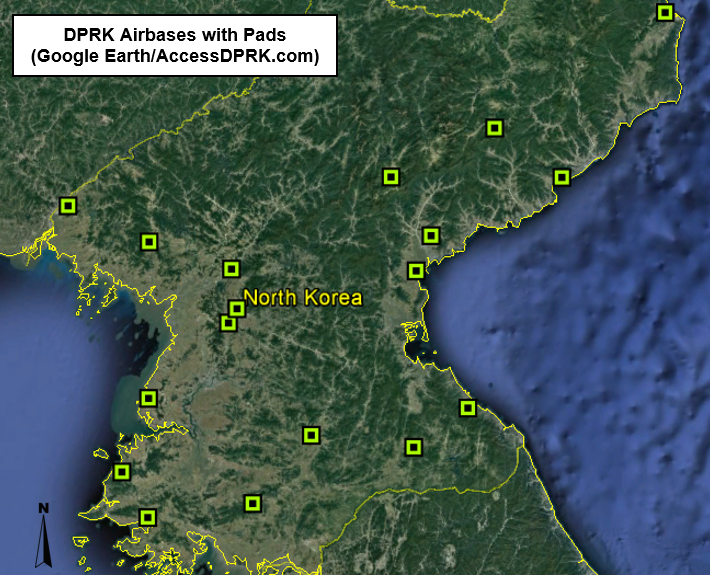
Those further changes to North Korea's military airbases and other runways, as well as the stunning advancement of their ballistic missile program makes it necessary for me to write, once more, about the ever-progressing nature of North Korea's military. There are three main areas of focus for this post. The first is the construction of multiple new aircraft parking revetments at new and older emergency runways. The second is the construction of more emergency runways. And the third deals with the possibility of the merging of North Korea's major airbases and ICBM program.


North Korea has 111 airports, airbases, heliports, emergency highway runways, and other landing strips. Particularly since 2016, nearly all of their emergency highway runways (straight sections of road that have been widened for use by aircraft in the event of a war) have had aircraft parking revetments constructed to augment each site. Additional basic runways have also had revetments constructed. In all, 15 airfields have had new revetments constructed. The number of revetments varies between one and four (most have three), but there is a grand total of 39 individual revetments which could support a combined 75 aircraft (at least) depending on type and parking arrangement.

It's important to note that not all of the satellite imagery of all of the different air facilities in North Korea has been updated to include either 2016 or 2017 imagery, so it's possible there are other sites that have had revetments constructed. I just can't yet see them.

Here are some examples of these sites. Click on any image to see an enlarged view.


Since my 2015 article on the North Korean Air Force and the changes that have happened under Kim Jong Un to the physical infrastructure of the Air Force and general aviation, at least three additional runways have been constructed.

Changdo, Kangwon Province (38.67993°, 127.72681°)


This runway is also approx. 3 miles (4.8 km) north of a military training base that underwent fairly substantial expansion in 2013.

Chongjin, North Hamgyong Province (41.80234°, 129.85480°)

This small auxiliary runway was constructed in early 2016.


Sunchon, South Pyongan Province (39.44058°, 126.03576°)

This runway is being constructed across from the large Sunchon Cement Factory. Curtis Melvin at North Korean Economy Watch believes that this will be a new 'executive' runway for use by Kim Jong Un and other high ranking officials. What makes it odd, in my mind, is the fact there are two large military airbases (and a helicopter base) within 12 miles (19 km) of this new runway - after all Sunchon is an important industrial city.
Perhaps the 30 minute drive was a bit too much for the Supreme Leader.


North Korea has a history of testing missiles from their airports, particularly at Wonsan (Kalama) and Pyongyang International. During the modernization and expansion of Wonsan, an observation facility was constructed as well as two concrete launch pads on the beach. And as you can see in the opening image of this article, Kim Jong Un observed the test of a Hwasong-12 ICBM from Pyongyang International. But unlike Wonsan, the Pyongyang launch was carried out on the bare ground.

Along the line of launch pads, there has been a curious development at 19 of North Korea's major air facilities. Starting in 2015 and extending into 2016 (such a busy year), twin squares of concrete began to pop up at these airbases. Unlike the small launch pads seen at Wonsan or other sites, which are approx. 60 x 80 feet (18 x 24 meters), these new pads are each roughly 165 x 140 feet (50 x 43 meters). All but two airbases have two of these pads, one at each end and directly in line with the runway's path, but not connected to it. The other two just have a single pad. Most are made of concrete, but a few are simply areas of cleared land and compacted dirt.


My initial thought was that these were helipads, but they're much larger than most helipads in the country. Additionally, these are military bases and space already exists for helicopters. Furthermore, Pukchang Airbase (near Sunchon) has an adjacent helibase with dozens of helicopters stationed there, yet the main airbase also has these new pads. Use of these sites for helicopters is also lessened because the pads aren't directly connected to the runway and are separated from them by around 170 feet (51 m).

I am not an aviation expert, but I have explored the globe via Google Earth (and been to a few airports) and I have yet to see this layout anywhere else. My second thought then became, what if these are actually meant to allow rapid deployment of various missile systems? (Their size would accommodate everything in North Korea's arsenal.) I have asked for the input of others but wasn't able to get much more than "that's plausible", with no other firm alternative explanations. So perhaps North Korea now has 36 new ICBM launching sites, or maybe it's something else entirely. The fact these things popped up across the country, basically overnight, are fairly uniform in size, and are only located at major military sites, impels me to at least bring attention to them.


These two images shows the pad area at Kaechon Airbase before and after construction.


This next set of images is just a sample of different bases with the pads.


Here is the list of coordinates for each of the airbases with these pads.
Changjin: 40.36680°, 127.26304°
Hwangju: 38.65468°, 125.78629°
Hyon-ni: 38.61354°, 127.45410°
Iwon: 40.36044°, 128.71995°
Kaechon: 39.76226°, 125.91326°  (only has one pad)
Koksan: 38.68810°, 126.60147°
Kuum-ni: 38.86713°, 127.90625°
Kwail: 38.42360°, 125.02213°
Nuchon-ni: 38.23767°, 126.11891°
Onchon: 38.90914°, 125.23311°
Orang: 41.43005°, 129.64906°
Panghyon: 39.92883°, 125.20714° (Panghyon is near the site of the July 4, 2017 ICBM test)
Pukchang: 39.50491°, 125.96567°
Sondok: 39.75929°, 127.47621° (only has one pad)
Sunchon: 39.41134°, 125.89543°
Taetan: 38.13016°, 125.24616°
Toksan: 39.98743°, 127.60276°
Uiju: 40.15111°, 124.49965°


My ego isn't so fragile that I can't handle correction. If you think (or know) I have misidentified these sites or can offer a plausible alternative, please let me know!


--Jacob Bogle, 1/30/2018
www.JacobBogle.com
Facebook.com/JacobBogle
Twitter.com/JacobBogle