Showing posts with label AAA. Show all posts

Coastal Defenses

April 27, 2013 Add Comment
North Korea's coasts are littered with defensive positions, a hodgepodge collection of modern defenses mixed with those remaining from the Korean War.

Their design takes a layered approach and is dependent on the topography of the area. Naturally, locations closer to the DMZ and those along the eastern coast (facing the historical enemy of all Korea, Japan) are more built up. To the southwest, the land border between North and South Korea gives way to a series of river mouths and tidal inlets, most notably at the confluence of the Imjin and Han rivers. This area opens up to the sea and is where I consider the North Korean coast in this region to being.

Within 3 miles of the Northern Limit Line (the de facto maritime border between the two countries, although it is disputed) are a series of observation posts located along the river banks, fences to the rear of the posts, a number of sand berms which divide up the patty fields, successive layers of road blocks and mixed throughout are anti-aircraft artillery sites (AAA), gun lines, trenches dug into the hills, and hardened artillery sites (HARTS). There are also ammunition caches and other storage facilities dispersed throughout.

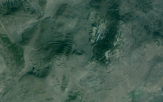
Here is a sample region.

(click images for larger view)

The Northern Limit Line runs in the middle of the river, naturally South Korea is to the south. The wider yellow line is the area I have marked as encompassing most of the border defenses which include the DMZ. It is approximately 3 miles (with some variation) from the NLL and the Military Demarcation Line which serves as the land border. The "P" icons are small position, observation posts etc. The red circles are HARTS positions, the "S" icons are storage facilities, "F" is for fortifications, the pink icon denotes bunkers or tunnels and the "policemen" mark road blocks of the type I discussed in this post

Here is an example of the sand berm and fence which runs the length of this region (as well as nearly all low-lying coastal areas).


To the north of this beach, in an area about 5 miles wide, there are 8 road blocks.


Now, moving away from the NLL here is a map of some of the small coastal positions located along the coast of South Hwanghae province. 


The island to the bottom right, labeled Keunyeonpyeong-do (also known as Yeonpyeongdo), is the South Korean island which was bombed by the North in 2010 which killed 4 and wounded 18 others. 

This is a close up of one of the larger positions. 


Literally thousands of miles worth of trenches can be found throughout the county. Some are left over from the Korean War and have no real use, but others are part of their active defenses. Like these:


Both east and west coasts are intermittently lined with obstacle courses aimed at preventing any rapid movement inland during an invasion. These "tank traps" consist of row after row of concrete blocks which have been sunk into the sand. The rows, usually 10 running parallel to each other, make up a full "band" around 100 feet wide. Most of these were put in place decades ago, some have been removed and others still have simply been covered up with drifting sand and mud. Still, in some areas they would slow any advance. They tend to be found in low-lying areas which lack mountainous terrain within a few miles of the coast and they are often paired with road blocks and berms further inland as well as rows of berms along the beach itself.

In this example the obstacle band has been marked in red, you can see the multiple sand berms in nice little rows.


And a close-up of the tank traps themselves:


Next is the defensive positions around a few coastal towns. If you look at the map I gave you above this area is roughly the 4 blue places marks in a cluster, to the north of Yeonpyeongdo Island. 


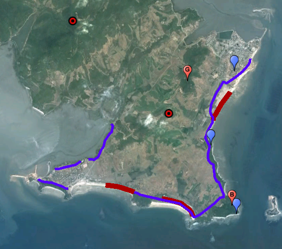
The blue lines are fences and the three red lines are the tank traps. As before, the red circles are HARTS, the blue marks are small positions, "G" is a gun line and "B" is a coastal battery.

Finally, these are just three additional images of some interesting coastal places:

An AAA site with trenches - 


A close-up of a hardened artillery site - 


And a reserve fleet of 10 ships. There are a number of these types of locations dotted around the coast. Some are just sitting in dry docks like these and others are actually housed in underground naval yards.


--Jacob Bogle, 4/27/2013

North Korean Artillery Sites

March 04, 2013 Add Comment
As I have mentioned before, North Korea is the most militarized country on Earth. They spend 20% of their GDP on their military (more than 5x higher than the US), males are required to spend 10 years in the military and at any given time 5-10% of their population is on active duty with an additional ~30% of the population in reserves or paramilitary units.

The country has successive layers of defensive positions, most notably around Pyongyang. This shows the location of many Anti-aircraft artillery sites (AAA) around Pyongyang and their ranges are shown by the circles.


One of the most common AAA platforms is the ZPU-4, pictured below.[1]

(Image source: Commons, CC 3.0)

This is just an example of the weapon and wasn't taken in the DPRK. It has a range of 8km.

There are currently between 1,500-2,000 AAA and HARTS (Hardened ARTillery Sites) sites in North Korea. Due to their economic difficulties and sanctions it is likely that 20-25% of the sites are non-functional (lack of parts, repair capability etc). Although it is very likely that the sites around the capitol and the DMZ are given priority and are functional.

While it is widely agreed that the technology and weaponry used by the DPRK is outdated and would offer little resistance to a full on assault by a modern military the fact that they retain such a vast number of guns and men under arms means that they represent a very real and credible conventional force.[2] Plus, they have special units trained in asymmetric warfare thus any land invasion would be an arduous and costly undertaking.

This realization and the ever-present reality that Seoul, South Korea lies within range of many of the North's weapon systems is why war cannot be considered as a series action. Should a war break out, within 48 hours it is estimated that South Korea could suffer 1 million casualties.[3]

There are two main layouts of their AAA sites and an asymmetrical layout. The most common is the "daisy" or "flower" design.


Here is a smaller version.


This is an example of a linear site. A number of traditionally "daisy" sites have been converted to linear sites.


An asymmetrical site. These are typically located along the thin ridges of low-lying hills or near populated areas lacking in uniform open spaces.


During the 1970's there were many more sites but over the years they have been removed or consolidated. I can only presume that it is because they lack the funding to keep all of them operational and that over the years many of the guns have broken beyond repair. This is one such site.


HARTS are largely a North Korean style of defense. They can take many forms but typically include AAA guns, SCUD missiles, SAM's, radar sites etc located in bunkers either cut into the side of a hill or in hardened facilities. Then they are rolled out into the open to be deployed. Some are also locations with gun positions cut into a hill or berm and are only covered by simple sheds. Although this might not sound all that secure the gun lines are very thin and are backup against a hill with tree cover. This presents a rather small target and depending on time of year they can be hidden rather well from aerial view.

Most of the artillery HARTS (HARTS can also be used to describe underground naval facilities and others) are located along the DMZ and there are 200-500 of them spread out along its 160 mile border. [4]


This is a typical position for the interior of the country.

And here is one typical of the DMZ. Note the small sheds.


Sources:
1. ZPU-4, Federation of American Scientists
2. North Korean Military, US Dept. of Defense
3. From Lambs to Lions, by Thomas Preston, pg 127
4. HARTS in North Korea, Nautilus Institute

Additional Reading:
Fortress North Korea, from GE user "Planeman_" at Militaryphotos.net
North Korea's WMD programs, Federation of American Scientists

--Jacob Bogle, 3/4/2013
www.JacobBogle.com
Facebook.com/JacobBogle
Twitter.com/JacobBogle

Mapping Project Update 1

February 24, 2013 Add Comment
In 2005 Mike Ane started a file containing several hundred locations of interest and then in 2007 Curtis Melvin and his associates at www.NKeconWatch.com greatly expanded the file by mapping the economic, cultural and military sites of North Korea using Google Earth. Their work brought to light thousands of locations and their KMZ file has been downloaded well over 151,000 times. However, as I would look over the country, I would spot something they had missed, and then it dawned on me that no private citizen (to my knowledge) has ever gone through the whole of North Korea, literally square mile by square mile, and marked every single item of interest.

So, a few months ago, I decided to take on that challenge. The work of Curtis and another avid GE user ( "Planeman_") laid the foundation and their descriptions taught me a lot about what places look like. For example, what an anti-aircraft artillery site looks like from aerial imagery, what an electric sub-station looks like, monuments, train stations and so forth. Building on that knowledge and what I have learned through hundreds of hours of research, I have been able to mark thousands of new places without duplicating the findings of others. 

This has been and continues to be a tremendous undertaking, but I think it is very important to shed light on a country so few know anything about. Even since Google Maps began, there was always a black hole in their data - North Korea - and it wasn't until a few weeks ago that Google began filling in the blanks, largely thanks to the work of individuals submitting information. It is my hope that in time North Korea opens up as a country, but until that time comes, I consider it worthwhile to use technology to reach out from my computer to data gathered from space and pull North Korea (or at least what I find) out of the void and bring it to the world. 

North Korea is divided into 9 provinces, 2 special cities, and the capital district. There is also the DMZ (Demilitarized Zone) which I count as its own geographic division. Each area has its own file which is then subdivided in categories: Military, Monuments and Domestic. Each category may have further sub-categories such as: Sub-stations, Irrigation control and Dams, AAA sites, Road & Rail Tunnels etc. I have been making use of the placemark icons and try to make them self-explanatory and use one icon for each different type of location to avoid confusion.  

The image below is a screenshot of all the places I've marked (excluding completed areas). Obviously, it looks like a mess and you're only seeing a handful of individual sites since they're all piled on top of each other, but I think it gives you some idea of what I've been doing and talking about for so long. 

(click for larger)

I have started files on almost every area and completed the DMZ, the Rason Special City and Ryanggang Province. It is my intention to publish the files once I am closer to completing the project, although I may publish what areas I've finished sooner. 

With completed divisions and the portions of partially completed divisions combined, I estimate that I am 25% finished and have marked roughly 2,200 items. The completed areas cover nearly 6,000 sq miles of territory out of NK's total land area of 46,541 sq miles. Due to the lower quality of some of the data there will be portions that have very few placemarks simply because the resolution is so low that specific individual items can't always be identified.

--Jacob Bogle, 2/24/13
www.JacobBogle.com
Facebook.com/JacobBogle
Twitter.com/JacobBogle

You can use the hashtag #AccessDPRK when discussing on social media.