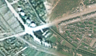
These resolution variances offer an interesting obstacle when it comes to mapping North Korea. Some of the images are merely days old with resolutions of such quality you can make out individual windows and see people walking in the streets.
(This image is about 750 feet wide)
And then there are other regions, mostly from France's National Centre for Space Studies (CNES) SPOT satellite, where the resolution is measured in meters. At this resolution you can only make out large structures, like the outline of houses.
(This image spans more than 2,500 feet)
Given the low resolution of the SPOT images, it can be almost impossible to definitively label something. Attempting to interpret an image is pointless in most cases. So, to help keep me (and others) from spending so much time scanning around trying to find an area of higher resolution, I've mapped out all of the larger low-res regions. Surprisingly, they make up a decent chunk of the country.
Once I've gone through the better quality regions, I will go over these low-res areas and mark whatever items I can find. You can download this file here.
Just for fun, I'm going to provide several examples of the different resolutions, colors, and seasons that one can find while exploring North Korea.
This is Pukchong, South Hamgyong. It is split between SPOT imaging and higher resolution images.
A town during winter
From MapABC, a Chinese company. Notice the poor coloration.
The same area in 2010 from Digital Globe
Battle of Pochonbo Monument
Monument closeup
A forest
And this is an example of what I call "foggy" imagery. I don't know what causes it, but it has nothing to do with actual fog/smog etc. It annoys me to no end because it makes it difficult to pick out certain features, like monuments or propaganda signs. Plus, it's just rough on the eyes.
--Jacob Bogle, 8/15/2013
www.JacobBogle.com
Facebook.com/JacobBogle
Twitter.com/JacobBogle


EmoticonEmoticon