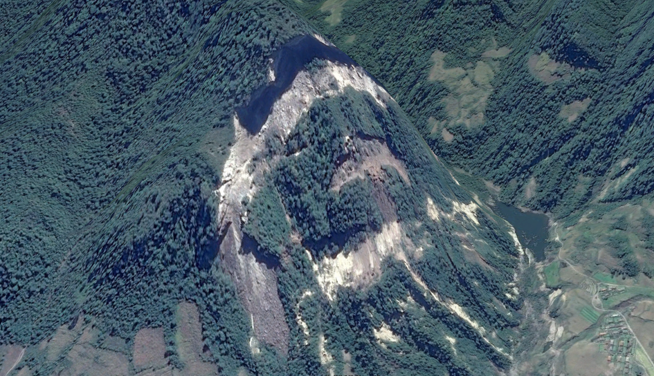
Looking at imagery from Myongchon County, North Hamgyong Province (near the Mt. Chilbo National Park), I found what seems to have been a major landslide.
Due to North Korea's mountainous terrain and frequent floods, landslides are a fairly common occurrence, but this one consisted of a 900 foot high hillside collapsing.
Here's the area on June 19, 2011:
And after the landslide in 2013:
--Jacob Bogle, 3/30/2015
www.JacobBogle.com
Facebook.com/JacobBogle
Twitter.com/JacobBogle
Due to North Korea's mountainous terrain and frequent floods, landslides are a fairly common occurrence, but this one consisted of a 900 foot high hillside collapsing.
Here's the area on June 19, 2011:
And after the landslide in 2013:
The crest of the hill is 894 feet above the valley floor below. The width of the collapse is nearly a kilometer, at 3,000 feet. It also interrupted normal runoff and thus created a small new lake (right-side of collapsed area). The lake covers about 4 acres (1.6 hectares). The exact coordinates are: 41° 7'33"N 129°30'39"E.
Here's a side view of the area before and after the event:
In June of 2011, there was major flooding in South Korea that also affected parts of North Korea. While it's impossible to tell when exactly this landslide occurred given available information, it's conceivable that the flooding in 2011 played a role.
The Mt. Chilbo area is a very popular tourist destination and is also an important ecological region. According to UNESCO, it holds 16 endemic plant species, 30 endangered plant and animal species, and has 132 medicinal plant species. The geologic origins of the Mt. Chilbo area come from volcanic eruptions relating to the Paektu Volcanic Zone (though, this particular area hasn't been volcanically active for millions of years).
www.JacobBogle.com
Facebook.com/JacobBogle
Twitter.com/JacobBogle


 adalah salah satu fasilitas di dalam VBA Excel untuk memudahkan tampilan output pemrograman.